These stories are based upon true incidents. Names and some details have been altered to insure confidentiality.
 In May of 2002, Freddy Griffen called for an appointment with me to discuss property he was interested in acquiring along Bayou Chat Blanc in St. Bernard Parish. After several minutes Marie was able to coax enough information out of him to identify the property in question, and she scheduled the appointment.
“Getting anything out of the guy was like pulling teeth,” Marie said as she advised me of the appointment. “He promised to bring a copy of the deed with him. I put what little information I could drag out of him on a legal pad. It’s on your desk.”
“Lot 2, Section 5, T15S/R12E” was the extent of the property information provided, so I retrieved a copy of the appropriate Government Land Office township plat. Lot 2 was one of four government lots along the bayou that bisected Section 5. I had information on GLO Lot 3, which had been subdivided into a waterfront subdivision known as Bois Du Lac in 1953. The easternmost boundary of Bois Du Lac subdivision was the westernmost boundary of Lot 2. I had no information on file pertaining to GLO Lot 1 that formed the eastern boundary of Lot 2. All of the lots were riparian to the north and fronted a highway that straddled the southern line of Section 5.
“Piece of cake,” I said.
“Écoute le Diable,” Marie cautioned from the next room. “The Devil is listening, and he will change your luck.” I grunted in agreement and chided myself.
Freddy Griffen arrived for our meeting on time carrying a thin folder of papers. He was a tall, lean man, about 30 years old and with the New Orleans accent of a Bourbon Street barker. After introductions, we retreated to my office to discuss the project.
The papers he presented to me were simply the realtor’s purchase agreement.
“I’m buying the Diaz land,” he said.
“Who’s the attorney handling the act of sale?” I asked.
“Diaz’s guy,” was the reply. My mental alarm bells began to ring.
“I mean your attorney. You are going to obtain title insurance, aren’t you?”
“What’s dat?” Griffen asked. It was becoming very clear that everything Freddy knew about real estate could be written in bold font on the head of a pin. I explained the concept of title insurance and the importance of an attorney.
“I don’ need dat,” he said. “Diaz’s guy’s okay.”
“Who is Diaz’s attorney? I need to obtain a copy of the deed.”
“Dis ain’t it?” He waved the purchase agreement around.
“No,” I said.
He provided me the name of Diaz’s attorney. I called the attorney to ask for the deed of record and an abstract of title. He promised to send them to me by courier.
The deed simply described the property as “Lot 2, Section 5, T15S/R12E, St. Bernard Parish, Louisiana” and referenced the GLO plat. It seems that Diaz’s great-grandfather had purchased the property from the U.S. Land Office in 1882, and it had remained in the family for the following 120 years. There was no abstract of title.
We recovered the control points for an old traverse along the highway and ran a secondary traverse north through Bois Du Lac subdivision, picking up as many lot corners as we could find. We were able to shoot east to a marina parking lot in Section 4 and traverse back to the highway, tying in the western boundary of Section 4 as we went. All the property between the range line and Section 4 was heavily wooded with no indication of possession. Nothing in the field or in the records I had found so far suggested that the line dividing Lots 1 and 2 had ever been monumented. The east line of Bois Du Lac subdivision was within 20 minutes of being parallel to the west line of Section 4 and roughly 2,700 feet apart at the highway.
I prorated a midpoint along the highway and prorated a direction north to the bayou. That evening I went over my plans with Pappy, my party chief.
“What you do’n pro-ain’ting, Boss,” Pappy said when I gave him the field data. Pappy always pronounced prorating as “pro-ain’ting” because, in his words, you “ain’t finding noth’n.” Pappy had been in this business for a long time.
“This is just a place to start looking, Pappy,” I explained. “The lawyer said this lot has had only one owner all of the way back to the U.S. Government. There has to be some kind of boundary evidence somewhere.”
The area had been actively cultivated years before refrigeration killed the local truck farm. The woods that covered the land now were only 75 years old or so. Beneath the trees there had to be some kind of evidence of use by the different owners; we just had to search hard enough.
I met Pappy at the road after the crew had cut the prorated line. We found nothing along the highway right of way. As we walked toward the north, I noticed the land rose slightly before leveling out again. A natural ridge, less than a foot change in elevation, ran across the prorated line toward the northwest at an angle of about 10 degrees. A very faint trace of wagon ruts followed the ridge. There was not a sign of possession, but it was curious.
“Find anything at the bayou, Pappy?” I asked.
“Rien,” Pappy responded. “Absolutely nothing.”
“Let’s walk along these old ruts,” I suggested.
We had traveled about 600 feet when the ruts faded out about 300 feet short of the bayou. I was tempted to simply prorate the boundary. There was no evidence in the field, the appropriate widths and areas were available, and the directions of the exterior boundaries were consistent.
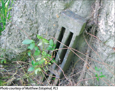
Then I saw a hackberry tree with some wire protruding from the bark. I stepped around one side of the tree as Pappy came around the other.
“Look at dat! What we done found here?” Pappy said.
It was a grate bar, the favorite boundary marker of colonial Louisiana.
When we got back to the shop, I called the attorney to ask if he could pull the deed for the owner of Lot 1 for me.
“What do we need that for? We know it is Lot 1,” he asked. “I ran the title on Diaz’s place back 52 years. It’s as clean as I’ve ever seen.”
“Was there a time when both Lots 1 and 2 were owned by the same person?” I asked.
“Fifty-two years—Diaz only owner of Lot 2, no complications,” the lawyer said.
I spent an afternoon in the courthouse and pulled the deed of the adjoining property myself. It referred to Lot 1 of the GLO and was accompanied by an unsigned sketch dated 1942, 60 years ago, when Diaz’s grandfather gave Lot 1 to a daughter. The sketch provided directions (to the ¼ degrees), distances (in toise), and had the initials “GB” at the corners.
It did not take more than a day to tie the grate bar into the traverse, and in the process we found another along that diagonal line. The distance between the bars matched the 1942 plat to within seven feet, slightly more than one toise. The boundary between Lot 1 and 2 had been set by the owner in 1942. I had come to within one step of prorating the line and busting a boundary for several hundred feet.
“The trick to findin’ sump’n,” Pappy said, “is to hunt where it’s at.”
I just looked up toward the ceiling and signed the plat.