Heights april 2017 Archives
UAS Regulations Update
A look at recent and near-future legislation affecting UAVs for geospatial business use. By Jeff Salmon BVLOS Update The ability to fly beyond line of sight (BVLOS) is paramount to a wide range of UAS operations, including utility and pipeline inspections and monitoring, open pit mining, precision agriculture, corridor mapping, large-area mapping and surveying, and […]
First Stop for Wandering Elf STEM Education
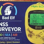
Franklin Community High School, Indiana First Stop: Franklin Community High School, Indiana xyHt, in conjunction with GNSS solutions provider Bad Elf, has kicked off an interesting STEM project that seeks to promote the physics and geodetic science behind GNSS. A Bad Elf GNSS Surveyor (a Bluetooth peripheral receiver for smartphones and tablets) has begun its […]
Remote Sensing in Yellowstone Park
A consortium demonstrates the value of integrated remote-sensing technologies for studying and monitoring the impacts of climate change using the northern range of Yellowstone National Park as a testing area. By Dr. Olaf Niemann, Dr. Robert Crabtree, and David Brown In 2014, a consortium between environmental scientists and an airborne remote-sensing company was awarded funding […]
15 Years of Growth at AXIS GeoSpatial

AXIS GeoSpatial provides more applications from one mapping effort. Easton, Maryland-based AXIS GeoSpatial LLC provides geospatial data and solutions to federal, state, and local government agencies and private sector firms, especially aerial mapping services. Heights talked with Erica Insley, marketing director for the firm. Heights: How did AXIS GeoSpatial get its start? Erica Insley: Founded in […]
Re-imaging Hells Canyon
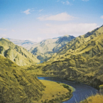
A geospatial company helps prepare for an environmental impact statement by scanning and orthorectifying historic imagery. Hells Canyon, North America’s deepest river gorge, encompasses a vast and remote region with dramatic changes in elevation, terrain, climate, and vegetation. Carved by the great Snake River, Hells Canyon plunges more than a mile below Oregon’s west rim […]
HSI on the Fly
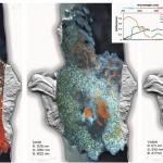
One company details mapping applications of airborne hyperspectral imagery for agriculture, forestry, and resource mapping. By Patrick Burns and Scott Nowicki, PhD Remote sensing imagery has been collected with many different camera systems for many different applications over the past 50 years of the industry. Visible remote sensing imagery provides interpretable information available to most […]