July 2018 Archives
Surveying Beyond the Water’s Edge

A remotely controlled unmanned survey vessel gives a land survey crew full hydrographic abilities for two busy marinas in Oregon. Founded in 2005, Statewide Land Surveying (SWLS) is a small business located in Gresham, Oregon, well acquainted with taking on challenging projects. While mostly engaged in land surveying, SWLS crew members have been involved for over […]
Where the Data Comes From

Members of Esri’s Living Atlas unit detail the company’s wide variety of data sources. For nearly 50 years, Esri has been developing and supporting GIS software. What is less known is that for more than 20 years it has also been collecting and curating data and making it available to its users. “It has become […]
The Future of Autonomous Transport

Geospatial technologies play a pivotal role for the Transport Systems Catapult, the UK’s not-for-profit innovation center for intelligent mobility. The town of Milton Keynes is at the heart of the UK’s transport revolution. It’s home to several tech start-ups and major transport-related brands, such as Network Rail (the UK’s rail authority), Leica Geosystems, Mercedes, VW, […]
Precisely Shot
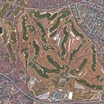
Aerial imaging, GIS, and GNSS play a crucial role in the success of golf’s 2018 U.S. Open Championship. “Basically, we need to construct a small city—every year and in a different location,” said Timothy Lloyd, senior manager of U.S. Open operations at the United States Golf Association (USGA). Lloyd’s team is charged with planning and […]
Slam an Entire Building

A Danish surveyor measured the floor area of 13-story building in 1.5 hours with a mobile 3D scanner. Accurately calculating the floor space area in a new building (either residential or office) has serious legal implications in Denmark, and this service has become important business for surveying companies there. One of these firms, LIFA Surveyors, […]
Full Tilt
Beyond the electronic bubble: Integrating self-calibrating, magnetically immune tilt compensation in a high-precision GNSS rover. This is not just another rover with an electronic bubble and tilt compensation. This new technology represents a genuinely significant step in the evolution of GNSS rovers. We are presenting this look at—and inside—the Leica Geosystems’ GS18 T not as […]