March 2019 Archives
Surveying & Safety
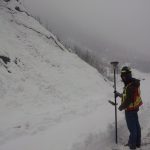
Above image: A surveying job made comfortable: Measuring a steep terrain from a safe ground location in the treacherous mountains of beautiful northern British Columbia, Canada. The importance of protecting our lifestyle. In this article, for the sake of brevity the concepts of occupational health and safety are referred to by the word “safety.” The […]
GPS Week Rollover – Don’t Panic (Update 3/28/19)
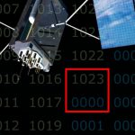
Updated March 28th, 2019: Unavco, the science cooperative that supports such projects as the Earthscope PBO GNSS and geophysical senor arrays, has launched a comprehensive WNRO page that addresses many of the receiver types they have deployed and includes some of their own tests. Updated March 26th, 2019: Trimble and Topcon have added updates to […]
RFID Crazy
Above image: A Berntsen RFID reader is being used in conjunction with a smart phone. RFID-enabled infrastructure marking could become a cornerstone for a connected infrastructure management world. Imagine if all public works engineers and utility company crew chiefs were equipped with a mobile device that could easily and accurately identify every piece of infrastructure […]
Nullifying the Noise
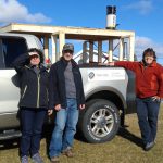
Image above: The Trifide crew of Ginette Allen and Hélène Gagné (with Herman Lavallée who rented them the truck) had to build a wooden rack and install it on the rented truck bed to provide a stable platform for the mobile mapping system. A female surveyor stays ahead of the competition and her critics by […]
BIM: Actual

On the rise are both interest and integration of processes—involving surveying, engineering design, and construction automation—into BIM workflows. Editor’s note: We can discuss BIM theoretically all we want, but we realize that, for many folks, the concepts might seem abstract until people see real-world examples. So we’re pleased to present the following project from a […]
Hayden’s Survey in 3D
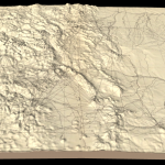
Above image: Hayden’s triangulation survey map is overlaid on a digital elevation model. A GIS project visualizes the fascinating triangulation network created for the historic Hayden survey of Colorado. One of the great surveyors in the American West is undoubtedly Ferdinand Vandeveer Hayden. A physician during the Civil war, he rose to be chief medical […]