Above image: A Berntsen RFID reader is being used in conjunction with a smart phone.
RFID-enabled infrastructure marking could become a cornerstone for a connected infrastructure management world.
Imagine if all public works engineers and utility company crew chiefs were equipped with a mobile device that could easily and accurately identify every piece of infrastructure underground and above ground—every gas valve, every water main or service line, every fiber optic cable, every transformer, and every light pole—and surveyors could use the same device to locate every survey marker.
How much time and money would that save? Given that 10% of underground utility damage events nationwide are due to visible but incorrect markings, how many such accidents would it prevent?
Radio frequency identification (RFID) technology already makes this vision possible, and I believe it should be applied to all infrastructure features as they are installed, repaired, or replaced. By connecting to a back-end database, RFID-enabled infrastructure marking would then become a cornerstone for a connected infrastructure management world.
A report endorses much of this vision: the September 2018 report for the Federal Highway Administration (FHWA) on issues associated with state transportation departments’ management of utility installations within highways’ right of way. It advocates the use of RFID for underground markings as a key step toward developing 3D inventories of utilities.
“Program benefits,” the report says, “range from the availability of geo-referenced utility segment data for establishing protection zones during construction to the development of a reliable inventory of utility features for asset management purposes and to facilitate future construction activities.”
Insights from Berntsen Intl.

Michael Klonsinski is Berntsen’s president.
Berntsen International, founded in 1972 and long known to surveyors as a provider of survey markers, has been working with RFID technology since 2006. It is steadily turning the above vision into reality with its InfraMarker product, a connected RFID locating and management system that utilizes RFID in a new way.
“We use the international standard and fastest growth UHF RFID frequency as a communications medium,” says Michael Klonsinski, the company’s president. “Asset management can start merging with location management because the same RFID serial number that triggers inventory control can be used for locations.”
Berntsen’s RFID Beginnings
Matteo Luccio: What is Berntsen’s market niche?
MK: Berntsen’s name is familiar to any American surveyor, and hundreds of thousands of Berntsen monuments mark the boundaries of federal and state lands. Today, Berntsen serves more than 6,000 customers with more than 1,200 marking products, and its products support boundary, utility, and trail marking.
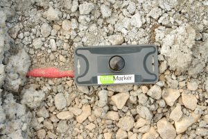
An InfraMarker device is attached to an underground conduit.
ML: How does the InfraMarker fit into your product line?
MK: Berntsen has a long history of being a top provider in physical marking products for boundary and infrastructure markets. Our strategic direction is to build on that physical marking to a smart and connected marking product line. Our goal is to take all our physical marking products and enable them with technology that allows them to be smart.
ML: Over time, are all your products going to incorporate aspects of this?
MK: That’s the ultimate vision, although there are certainly some traditional products that will always stand on their own. The original driver behind InfraMarker—more than 10 years ago—was to incorporate some type of technology on our survey monuments that would provide surveyors with more information in the field. RFID was an early candidate for that type of smart technology.
From there, that type of RFID approach took off into more of a utility-locating and marking product. We’ve experimented with and piloted sensors within some of our marking products. We would love to have our entire catalog consist of technology-enabled, smart markers.
ML: What were the main technical challenges that you saw when you began to develop InfraMarker?
MK: There were many technical challenges, but the biggest was that the connected infrastructure system did not exist. We could optimize UHF RFID tags to operate in dirt, but the connectivity of that information pathway to mobile field applications, the cloud, and ultimately an end-user’s GIS simply did not exist. We had to develop, partner, or anticipate how the connected pathway would evolve.
ML: How did you address that?
MK: When we first were doing this, before 2013, the idea was that there would have to be customized readers to do that. But we recognized that eventually these field data collectors would have to be connected to something else and eventually to a back-end system. So, we developed our own prototype field data collection module with RFID extendibility, and then we also built a rudimentary back-end GIS to be able to support that, at a time when all that connectivity didn’t exist.
As the technology evolved and we realized that this was the right direction, we started partnering with another organization in developing some of the connectivity for the technology that was already in place. We decided that iOS and Android phones would be the option for the future. So, instead of developing a custom product, we decided to build on the existing technology as it was going.
We partnered with organizations that were doing mobile data collection to GIS integration. Eventually, we took what we had developed as a prototype and turned it into a more robust system—from ground to cloud and back.
Current RFID Uses
ML: What has changed since xyHt’s April 2015 cover story on RFID?
MK: The world has changed dramatically in the past four years. Mobile devices as data collectors have become more mainstream. Cloud storage is the de facto choice. Integration with GIS has become easier. Also, the market continues to move to the recognition that easy access to shared data is more valuable than siloed solutions.
ML: What are examples of the more advanced experiments?
MK: The early adopters are the utility-locating firms that are using it as a service to differentiate themselves from the competition, particularly potholing applications. Those are some of the applications where the contractors are seeing their roles not simply as locators but as purveyors of information, as well.
That is where the connected RFID solution thrives, because it links the locating and verification in the field service with the data communications requirements of the asset management world.
ML: Roughly what percentage of state and local governments and utility companies are routinely using RFID in new construction? What is their motivation?
MK: That’s hard to say. There are many asset owners that have used and are using RFID in the old locating sense, i.e., using different RFID frequencies to identify an asset below ground. There are organizations that are using UHF RFID for tracking and inventory of assets (such as tools) but not coupling it with the geolocation component.
There are not as many that are using RFID for locating and communicating information as part of an infrastructure management solution. That is coming.
ML: Which technologies are complementary to RFID and which are in competition with RFID?
MK: In the old-school sense of RFID for locating only, competing technologies are locating techniques such as GPR, tracer wire, magnetic detection, etc. In the world of asset management, a comparable or complementary technology might be bar codes. We believe that connected RFID bridges the gap where it serves more accurate locating and provides advantages of real-time connectivity to data and infrastructure management systems.
RFID was used to help differentiate enemy aircraft from friendly ones in World War II. If you were able to match the frequency of an RFID with the aircraft returning from Europe, then you could allow it to pass the home borders rather than targeting it. It was more about different frequencies of use to distinguish what you were looking at.
Most RFID today—whether in tollways or RFID chips in shirts or in your pets—does not depend on different frequencies but is a standard channel for communicating information embedded on the chip to a receiving antenna. That is why UHF RFID is one of the most rapid growth technologies in the world today. It is a standard, cheap, and easy means to transmit information.
For example, to drive through tollways, trucks, busses, and cars get the same RFID antenna. It is the back-end database that reads whatever information is on that RFID chip to tell you what it is, how to bill your credit card, and all of that.
Users tend to think of RFID as either an alternative to GPR or tracer wire or as an inventory management technology. We are saying, “You can have it both”: RFID can enable better locating and be a stable identifier for managing your assets.
ML: On what grounds does the FHWA report advocate the use of RFID?
MK: Primarily the need for in-field verification. Despite all the mapping and virtual technologies that are in place, there is still the need for verification and more precise identification in the field. RFID provides that.
ML: What do you mean by verification?
MK: Some people—especially the tech group—think, “If we have maps on our phones and precision GPS, why do we even need anything in the field?” However, field operations people know that you still need to confirm that you are where you are supposed to be and accessing the right asset when you are standing there in the field. No one wants to bet their life by digging based on the point on the map. One of the things that the FHWA report emphasized is that you still need a physical verification or validation for the field locator.
RFID and IoT
ML: What is potentially RFID’s role in building a smart city?
MK: At the risk of going too over the top, there is some truth to the statement that “RFID is the serial number of the Internet of Things [IoT].” RFID can be read above and below ground, placed on almost any asset, read with standard RFID readers, and generally turn any “thing” into a common serial number that can be used in many systems. A smart city depends on a connected infrastructure. RFID tags can provide that bridge between the physical assets and the cloud-managed infrastructure.
ML: Why tag IoT devices? Don’t they all already have their own identifier?
MK: Some do, but they also have different identifiers depending on their use. A UHF RFID chip provides a standard serial number regardless of use and can be applied to almost any device. Currently, there is no standard IOT serial number.
ML: However, you would know whether it is a refrigerator or a car, you would have some ID for it, and you would know its location.
MK: It is a data unifier challenge: How do you identify, in a standard way, say, what is in your right of way? One method is to have an RFID chip or some type of sensor-enabled RFID chip that would tell you what device is talking to you or what asset you are inspecting. Ideally, you want to interrogate each product with the same device and UHF RFID offers that potential. It’s already a standard.
Let’s say that you are a city manager and are responsible for tracking all your infrastructure, from tools to stop signs to fire hydrants to catch basins to trucks. You could put an RFID chip on every one of those things. Then, the manager could do asset management and location management using the same RFID equipment. You could tie that into your asset management, your compliance system, and your workforce management systems, all at once.
ML: What is going on in the world of standards, regarding development of a universal RFID numbering system and how it relates to IoT?
MK: One of the beauties of using RFID is that since 2010 it has been an ISO standard for serial numbers. So, that is pretty set. We don’t have to worry now about people in the serial number portion of the chip. We have a standard that we are willing to share about infrastructure location for some of the variable portion of the tag. That includes such things as lat/long, asset owner, and asset description. We see that standard as developing. Certainly, we want to promote a standard around that. But the basics of the RFID standard are already there.
RFID Crazy
ML: What would be the benefits of going “RFID crazy” and tagging everything, above and below ground?
MK: Use of common, accepted marking across all assets. Cheaper management. More effective validation of asset management and location. Better integration with multiple systems.
ML: Is all of this changing the nature of your company, from selling markers to building back-end systems?
MK: We do not intend to be a GIS company, but we do recognize that we are a company that has always been, and always will be, critical for a location-indexed world. We certainly understand how our products enable GIS and support accurate field data collection. Likewise, we are not a cloud provider, but we know how to get quality information to the cloud.
Berntsen has always been and always will be focused on providing the highest quality physical marking products. It’s just that those products will include data communication technologies as well as benefit from our years of understanding how marking products survive in the outside world. We’ll work on the “ground-to-cloud” delivery for the connected world.