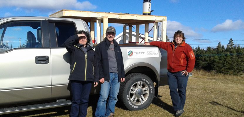
Image above: The Trifide crew of Ginette Allen and Hélène Gagné (with Herman Lavallée who rented them the truck) had to build a wooden rack and install it on the rented truck bed to provide a stable platform for the mobile mapping system.
A female surveyor stays ahead of the competition and her critics by frequently combining different technologies and trying new ones, recently a mobile-mapping system.
Anyone familiar with Chantal Arguin would likely tell you that she doesn’t care for the word “no.”
“When someone says ‘no’ to me and they don’t have a good reason, I will listen to them, but I will do what I wanted to do anyway,” says Arguin, a professional surveyor/entrepreneur.
“That word is a good motivator for me. Always pushing for more is in my DNA.”
That drive is what propelled Arquin to become a licensed land surveyor in 1991, a sector that was only 4% female in Quebec then and has risen to only about 13% today. That same drive pushed her to become the first woman and the youngest president of the Quebec Order of Land Surveyors, the province’s association for professional surveyors, in 2000. She was unanimously elected, quieting male critics who were unsure a woman could lead the organization.
It was also that same drive that led her to start and lead not one but two companies—geomatics company Trifide Group in 2002 and, at the request of Trifide customers, Arguin and Associates, a land surveying company in 2010.
Since opening her businesses, her aversion to the word “no,” her proven geomatics expertise, and her love of technology have been the driving forces behind her can-do attitude, her growth mindset, her commitment to trusting her instincts, and her success. It has been a winning formula, and a particularly necessary one in an increasingly competitive market where smartphones and consumer-grade drones are threatening professional surveyors and geomatics professionals’ livelihoods.
Her Differentiating Factor

Chantal Arguin is not a fan of the word “no.”
When Arguin launched Trifide Group, its core business was providing 3D city-scale photo products and photogrammetry services. That was quickly eroded by the arrival of Google Earth and other similar free or low-cost sources of satellite imagery with sufficient resolution for large-scale mapping and planning.
Undeterred, Arguin adopted new technologies to shift to 3D mobile mapping and specialized photogrammetry services. She systematically and strategically acquired new tools at every turn to advance and expand her offerings to include laser scanning, thematic mapping, marine mapping, bathymetric surveys, GIS consulting, and land and construction surveys.
When the volume of requests for land surveying became too high, that part of the business was spun into Arguin and Associates.
Between the two companies, Arguin’s mix of technologies includes 3D mobile mapping, laser scanners, GNSS receivers, total stations, unmanned aerial systems, and a host of processing and extraction software specified by clients.
“When everybody goes right, I want to go left,” says Arguin. “That’s why I’m always trying new technology and combining different technologies to be more successful and more competitive. We have to be the first ones to try new technology to understand how we can make money with it. I believe if you aren’t in front, you won’t win.”
In addition to building a technology advantage, she leverages her expertise in surveying to ensure all her deliverables are georeferenced and certified—a needed competitive edge to combat the trend of “laypeople” selling products and services once offered only by geospatial professionals.
“With consumer-priced drones and iPhones, we now have to compete with people who claim they can lay out property corners or provide aerial surveys,” says Arguin. “And with Google Earth and Google Street View, you can get satellite imagery for free. But many clients require georeferenced information and the certification that the geopositioning is accurate. Google can’t provide that and neither can a person with an off-the-shelf drone or smartphone.
“So my competitive advantage is that I’m a qualified, professional land surveyor, and my staff are geospatial professionals, so every time we deliver data it is certified data.”
Remote Mobile-mapping Survey
In addition to providing certified data to differentiate herself in the market, it is Arguin’s penchant for saying “yes” to complex projects and difficult situations that has also set her apart. One of the most recent examples of this was a mobile-mapping survey in Quebec’s remote Basse-Côte-Nord (BCN) territory, a stunning 400-kilometer (250 mile) stretch of wild coast, home to some of the oldest fishing villages in Canada.
Known in English as the Lower North Shore, the northeast region is home to 14 formerly self-sufficient communities of French, Innu First Nation, Acadian and English speakers who dot this rocky, weather-beaten expanse where the Atlantic, the boreal forest, and the tundra converge.
The task was to acquire 3D mobile-mapping images of the roads in eight villages and five provincial airports within the BCN. The catch was that none of the eight villages is connected by roads, and the only way in or out is by air or boat.
“Access alone to these places is enough of a challenge, but some of the roads are nearly impassable,” says Arguin. “Since we would have to travel between the places by plane or boat, we’d need to rent a vehicle each time, so the imaging setup would be different for every vehicle. Traditional, fixed mobile-mapping systems wouldn’t work.”
Arguin met the challenge the way she’s always done: she adapted and found technology that would work. In 2016 she purchased the Trimble MX7 mobile imaging system specifically for the BCN project.
Into the Wild
The aim of the BCN project was to collect georeferenced, 3D images of the selected villages and airports to enable government authorities to inspect the quality of roads, runways, and taxiways from their desktops. Such detail would allow them to identify areas of damaged roads or runways and then prioritize and plan for badly needed maintenance and repair work.
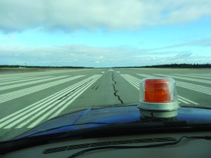
The two-person team captured 12 mi of airport runways and taxiways for the project.
The chosen villages included La Romaine in the west, Chevery, Tête à la Baleine, La Tabatière, and the eastern-most town of Blanc Sablon. The roads and airport of Anticosti Island, south of the BCN, also needed to be captured. In total, the two-person Trifide team had to cover 424 km (263 mi) of roads and 20 km (12 mi) of airport runways and taxiways.
“The compact size of the imaging system would make it easy for us to transport the unit by air or boat and install it on local vehicles,” says Arguin. “And its ease of use and comprehensive imaging would allow us to handle the whole project with only two people.”
On top of the logistical travel complexities of the project, Trifide was required to work around the tight schedules of each airport’s traffic––no runways or taxiways would be shut down to conduct the work.
On a cool morning in mid-October in 2016, Hélène Gagné and Ginette Allen, Trifide team leaders, flew to the 7,923 sq km (3,059 sq mi) Anticosti Island, the largest—and unexpectedly challenging—sites of the BCN project. They hit their first snag before even leaving the Port-Menier Airport.
Their only rental car option was a pickup truck, meaning there was no roof rack to install the mobile mapper. So, the industrious crew built a customized wooden rack and installed it in the truck bed to provide a stable platform. Having resolved that, they moved to the next challenge: how best to contend with the 302 km (188 mi) of unpaved roads––some nearly impassable––that they needed to cover.
To accurately georeference the images, the crew faced 188 mi of unpaved roads, some nearly impassable.
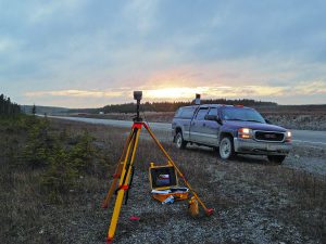
Choosing the optimal route, they first set a control point and collected two hours of data with a Trimble R10 GNSS receiver. With control established, they mounted the MX7 and began driving the island’s main road at speeds of 40 km/hr (25 mph) (or less, given the terrain) as the mobile mapper captured a 3D image every five meters (15 feet). To ensure they could accurately georeference the images, they set up the R10 at 40 km (25 mi) intervals.
“The MX7 is equipped with a GPS receiver and an inertial measurement unit,” says Arguin. “By combining that data with the data from the GNSS base station, we could obtain a precision of about 20 centimeters (0.7 feet) in our environment conditions.”

The Trifide team had many encounters with deer on Anticosti Island.
In three days, Gagné and Allen had imaged the island’s road network and its airport’s runway and taxiway––and became friendly with several curious white-tailed deer.
From there they flew back to BCN to the village of La Romaine, an Innu First Nations reserve, to capture its 13 km (8 mi) of roads and its 1-km-long (0.6 mi) runway. They then either used planes or ferries to reach the rest of the villages.
In each place, the team’s ritual was the same. They established control with the R10, mounted the mobile mapper on their vehicle, plotted their acquisition route, and drove carefully, avoiding the large potholes, sizable cracks, and boulders that riddle many of the roads. In total Gagné and Allen collected 180,000 3D images in 11 days.
“With the rough state of the majority of the roads and the tight logistical timelines we had, we needed a rugged, reliable and lightweight system,” says Arguin. “We could attach the MX7 in minutes and with a 360-degree, high-resolution camera, we could capture all directions in one pass.”
After each day in the field, the Trifide team downloaded the images using Trimble’s mobile image processing software and checked the imagery for clarity and precision. They then used the Applanix POSPac MMS software workflow to directly georeference all 180,000 images. With this process, they created individual image sets for each village and airport that met the GIS positional accuracy requirements and delivered them to Trifide’s customer.
“With this technology we were able to produce highly detailed, 3D inventories of each village’s road and airport infrastructure in a little over a week,” says Arguin. “Given the remoteness of the area, having such precise visualizations gives authorities the ability to inspect any segment of any road, from their own distant office, and create targeted repair and maintenance programs. It’s an efficient and effective development and management tool.”
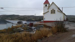
A church in the village of Mutton Bay near La Tabatière: an example of the remote areas that needed to be captured in 3D.
New Tech, Old Roots
Given the success of their debut project with the mobile mapper, Arguin has since racked up thousands of kilometers with it.
They’ve taken it to small airports to image runways and taxiways for pavement analysis. They’ve used it for the shoreline inspection of a lake in the Quebec city of Choeinguan to provide local authorities with a baseline inventory of the riparian vegetation around the water. Such a foundation enables them to image the vegetation coverage over time and assess if there have been any violations of riparian vegetation regulations.
And they used the technology for the Port of Montreal. With the MX7 mounted on a boat, they surveyed 26 km (16 mi) of ship channel. The images enable the Port to inspect the channel walls and bollards to check for wear or damage.
In addition, Arguin has been using her persistence and persuasive powers to expand her 3D mobile mapping business to the city level. In a way, she’s been trying to return to her founding roots of providing 3D city-scale images.
“Typically, cities contract surveying companies to create signage inventories or other asset inventories––work we can absolutely do with our GNSS surveying technology,” says Arguin. “They are expensive projects for the city because they take a lot of time and personnel to complete the work. With my mobile mapping system, I can beat by the traditional survey method by about 70%. That’s speed and value for money.”
She may be making some progress. She recently presented the benefits of mobile mapping to a municipality––the same city she’s been talking to about the technology since 2010––after they finally expressed interest in adopting it.
But for Arguin, the long game is what motivates her. And she’s been skillfully playing it ever since she was snubbed by male surveyors early in her career. She still hears critical comments, but she tends to bat them away. Instead, Arguin remains focused on her mission––to prove by doing, to learn, to push herself and her technology, to leverage her land surveying and geomatics expertise to provide certified data, and, above all else, to ignore the negative noise.
“If I had let naysayers influence my career, I might not have pursued surveying,” says Arguin. “Thank goodness I didn’t listen, because being a licensed surveyor is my most valued possession. It’s what allows me to do what I do and be successful. I would never give that up.”
Some might say, “yes” to that.