Seeing down manholes in detail is an innovation made possible with 3D scanning.
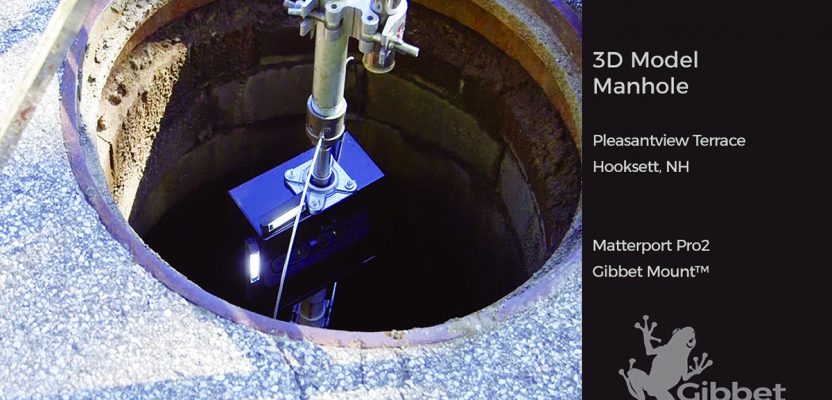
[Above image: Deploying the camera system down a manhole to access the Hooksett, New Hampshire sewer system. No breaching of the hole happened, which is a serious OSHA consideration. (The GibbetMount shown here has a steel casing that’s since been upgraded to a plastic housing with integrated proximity sensor and LED lighting.]
A manhole, a mine shaft, and any such underground place where people work are among the most dangerous working environments. Engineers, construction and utility professionals must attach a sniffer before they descend into many holes due to the possibility of methane gas and any number of noxious gases.
However, the dangers and challenges of surveying manholes are diminishing as new products enter the AEC industry. For example, engineers can now have access to 3D visualizations of underground conditions without ever descending into manholes.
I launched my business, Hubcam, in New Hampshire, capturing residential and commercial real estate photos. Now we create immersive 3D virtual tours, aerial photos and videos, HDR photography, and informative floor plans, mostly still for the real-estate market. For surveying manholes, we use the combination of 3D video and photography, coupled with our own mounting device, to make visualizations.
Utility, engineering, and construction leaders can similarly evolve surveying techniques using interactive visualizations.
Early Start
I was visiting with a buddy of mine, explaining how I use the Matterport Pro 2 camera in my line of business. He suggested the camera would be particularly useful in engineering spaces, especially waste-water treatment facilities.
He also suggested I explore how to send a 3D camera down a manhole so engineers might gather better data in potentially hazardous or inaccessible environments. That conversation is what inspired me to develop our GibbetMount device that works with that camera.
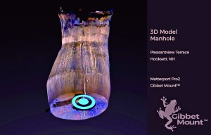
This “dollhouse” view of the manhole is a 3D model created with Matterport software.
Currently, many engineers are attaching GoPro cameras to pole cams. However, the video produced by this method is not sophisticated enough for engineers to study video models and take measurements for pipes.
We built the GibbetMount device around the Matterport Pro 2 camera based on the visual representation you need to capture. For example, engineers might identify staining along bricks in the imagery and determine there is water intrusion from a collection of XYZ coordinates on a point cloud. AEC professionals can export the data as a point cloud into Revit or any CAD program for further workflow.
The Matterport Pro 2 camera mounts standard from the bottom, where the motor is located. This works well for most site surveying. However, manholes require the camera to be lowered into the chamber from above with a mounting device, supporting, protecting, and allowing the camera to rotate freely. It also needs a stabilizing platform mounted to the top of the device so the camera scans and rotates freely.
We created this design, then included LED lighting and a proximity sensor. I know the Matterport camera does a good job of “seeing” on its own with infrared technology, but I integrated an additional external light source with an LED system designed to pick up additional detail in the manhole environments.
We also configured a vehicle-mounting system for any vehicle with a square-mount hitch.
Our tool has a ground sensor, informing the operator at the surface how close they are to the bottom. That’s pretty important when you’re 20 feet above your camera and you don’t know the depth of the hole. You don’t want to put your GibbetMount or your camera into water, or a sludge pit, or any number of nasty places.
You can scan an entire manhole, 15 feet deep, in about five minutes, conceivably scanning and capturing 10 manholes in an afternoon. That’s 3D innovation.
Contact: John Hubbard
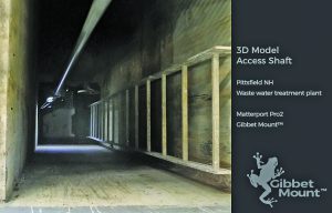
Deploying the camera system down a water-filled access shaft with a pump at the bottom.
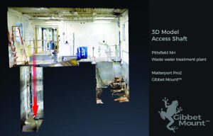
A “dollhouse” view of the access shaft as a 3D model (the added red arrow denotes a point of access).
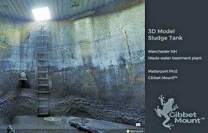
A detail view of one camera position within a 3D model.
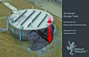
An aerial drone combined with 3D view of a sludge holding tank shows points of access.