xyHt in print September 2015 Archives
NGA’s Involvement With Our World

Above: The deputy director says that NGA wants to have a bigger role. Editor’s Note: On July 23, xyHt editors Gavin Schrock and Dave Doyle were invited to address an audience of professionals at the headquarters of the federal government’s National Geospatial-Intelligence Agency (NGA) in Springfield, Virginia. While this was a closed-door session held to […]
Common Research Mistakes Surveyors Make, Part 2
Road Records, Easements, and Probate Records In a previous article (July 2015) I explain two of the five common mistakes made by surveyors in researching the records: mistakes made in determining senior title and the deficiency existing when a forward search is omitted. The remaining of the five common mistakes often made by surveyors are […]
Raising the Roof
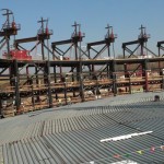
A survey company changes its tactics to monitor an auditorium roof before, during, and after its lift into place, using teamwork and true professionalism. American Surveying & Engineering, P.C. (with corporate headquarters in Chicago, Illinois) was approached by JP Cullen (a contractor with headquarters in Janesville, Wisconsin) with a challenging project: a particularly tricky auditorium […]
Going for the Long Shot

Intuicom’s RTK Bridge has come a long way, including use for hydrographic surveying. Editor’s note: A product name can become a default term for a particular solution; this is the case with the RTK Bridge, a trademark name for the product that Intuicom, radio communications component company, began working on nearly a decade ago. And […]
Hydro Insights

This visualization is of the high volume of commercial shipping activity into and out of ports rimming the Pacific Ocean. The data were analyzed using Esri’s new GIS Tools for Hadoop toolkit. Visualization by Mansour Raad, Esri. Available online at coolmaps.esri.com/BigData/ShippingGlobe with any browser running WebGL. Part 1: Uncharted Depths Editor’s Note: xyHt is honored to […]
Capturing the Wind
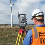
A one-person crew provides foundational data for building a massive wind farm in Australia, using integrated survey technology. When you look at the commanding stature and aesthetically pleasing symmetry of the turbine towers at the Mt Mercer Wind Farm in southeast Australia, it is easy to gloss over the central role that surveying and engineering […]