Siberian State University of Geosystems and Technologies
Editor’s note: The name, “Siberia” evokes visions of a vast, cold, and perhaps foreboding place. Vast, yes, but also beautiful, steeped with fascinating history and resources and home to a diverse population imbued with a pioneering spirit.
To meet the demands for qualified surveyors for the region, a unique school has grown over eight decades into an international magnet for surveying and geomatics education and research. We had the pleasure of meeting Dr. Musikhin and some of his students at INTEGEO 2017, where we asked for this profile.
Our school was founded as the Siberian Institute of Astronomy and Geodesy in 1933 in Omsk, Russia’s second-largest city east of the Ural Mountains. The next year the institute was moved to Novosibirsk, where it temporarily joined the Novosibirsk Institute of Civil Engineering as the department of geodesy. In 1936 it was reorganized into the Novosibirsk Institute of Geodesy, Aerial survey and Cartography (NIIGAiK).
After that, the institute was known as Novosibirsk Institute of Geodesy and Cartography, Siberian State Academy of Geodesy (SSGA), and finally now it’s the Siberian State University of Geosystems and Technologies (SSUGT).
Currently, the university has an enrolment of about 6,500 students and offers 24 bachelor’s, master’s, and PhD programs hosted in the three institutes: Institute of Geodesy and Management, Institute of Optics and Optical Technologies, and Institute of Cadastre and Environmental Management.
Russian residents make up the bulk of undergraduate and postgraduate coursework enrolment, although international students, mainly from CIS (Commonwealth of Independent States, a region comprising several former Soviet Republics), nearby Asian countries, and a smaller number from middle-eastern and African countries, make up more than 17%.
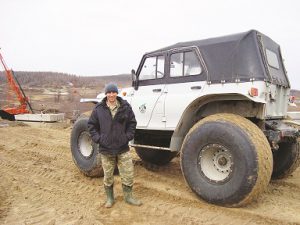
Getting ready for an expedition in the suburbs of Novy Urengoy, Yamalo-Nenets Autonomous Okrug, Russia.
The university provides a large spectrum of unique degree programs in geospatial surveying engineering, geospatial computing sciences, photonics, and optical instrument and device making. The degrees are supported by the largest GIS and geospatial surveying engineering endowment in the Ural, Siberian, and Far East regions of the Russian Federation.
The university’s faculty consists of highly motivated and enthusiastic teams of internationally experienced teachers and researchers who are determined to open the doors of opportunity to students for a range of spatial science career routes. All new faculty had field work and/or research experience before joining academia.
NIIGAiK-SSGA-SSUGT is recognized throughout Russia for providing leading university-level teaching programs in aerial, mine, and engineering surveying, GIS, photogrammetry, remote sensing, cartography, optics, optical technologies, and related fields. The university is an acknowledged leader for research of national and international significance in the areas of photogrammetry, remote sensing, GNSS, geodesy, GIS, optics, photonics, and laser scanning.
Unique Qualities
Compared to many other technical universities in Russia, Siberian State University of Geosystems and Technologies has incredible training and program support from various state and private geospatial companies, R&D centers, and research institutes, allowing its undergraduate and graduate students to get an enhanced and intimate experience as well as necessary skills to be industry-ready when they graduate. They gain experience through field trips, camps, expeditions, work placement and experience, work-integrated learning activities, guest lectures, networking events, and out-of-class learning and research activities.
Much credit can be given to the current faculty of the university who have been crafting and molding specialists for almost 85 years.
Research
The university has a strong tradition of producing nationally and internationally significant research outcomes, regularly investing in novel methods and new technologies related to the spatial sciences and drawing expertise from a wide range of disciplines. The engineering and scientific research groups are: remote sensing, photogrammetry, UAV/UAS, GNSS, geodesy, GIS, laser scanning, and geodetic monitoring.
Significant projects of recent years include the development of:
- a regional emergency management system,
- an automated geodetic deformation monitoring system,
- a regional GIS portal,
- digital photogrammetry, including airborne laser scanner-based data acquisition and processing; automatic pattern recognition from multi-spectral satellite images; development of hyperspectral imaging techniques and artificial intelligence,
- landscape/ecological research of natural and technogenic systems and complexes,
- laser scanner-based data acquisition and processing, including the creation of 3D models of complex road networks; geodetic monitoring of man-made structures and natural objects; DTM generation, and
- theory, models, and methods for high-accuracy GNSS positioning, including the development of an active GLONASS/GPS base station network for the Novosibirsk region.
Partnerships
The university’s training programs are able to prosper and continue to be viable by building and maintaining strong educational, research, and industry partnerships with
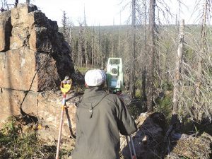
Surveying in the Siberian Taiga (one of the world’s most expansive boreal forest regions).
Russian and foreign universities, companies, and organizations. For many years, we have maintained vibrant educational, research, and industry partnerships with the:
- International Society for Photogrammetry and Remote Sensing,
- International Association of Surveyors,
- International Cartographic Association,
- Wuhan University,
- Stuttgart University,
- Hannover Leibniz University,
- Michigan Tech University,
- Mongolian State University of Science and Technology,
- Haifa University,
- Moscow State University of Geodesy and Cartography,
- KTH Royal Institute of Technology in Stockholm,
- Siberian Branch of the Russian Academy of Sciences, and
- Russian companies such as Gazprom, Rosneft, LUKOIL Oil Company, Sibneft, Surgutneftegaz, ALROSA, and others.
Through these partnerships, the university’s staff and undergraduate and graduate students are able to be involved in ambitious R&D projects.
Interexpo GEO-Siberia
Since 2005, the Siberian State University of Geosystems and Technologies has held the annual International Exhibition and Scientific Congress Interexpo GEO-Siberia, the largest national event in the field of geospatial technology and science. Here, professionals from all over the world, as well as undergraduate and graduate students, come together to learn more about new trends in geospatial technology and applied sciences from other professionals.
Selected speakers give presentations on their areas of expertise within the fields of GNSS and precision navigation; technologies of geodetic monitoring and control; cartography; photogrammetry and remote sensing; laser scanning technologies; geospatial intelligence; emergency situation management; smart city solutions; information security; land management; big data; BIM; GIS; laser assisted micro- and nanotechnologies; optical engineering and instrument-making; water, land, and forest resource management; and advanced educational technologies in the professional sphere.
Interexpo GEO-Siberia offers graduate students from different universities a remarkable opportunity to exchange their experiences within a Master Scientific Session.