A profile of their geomatics program
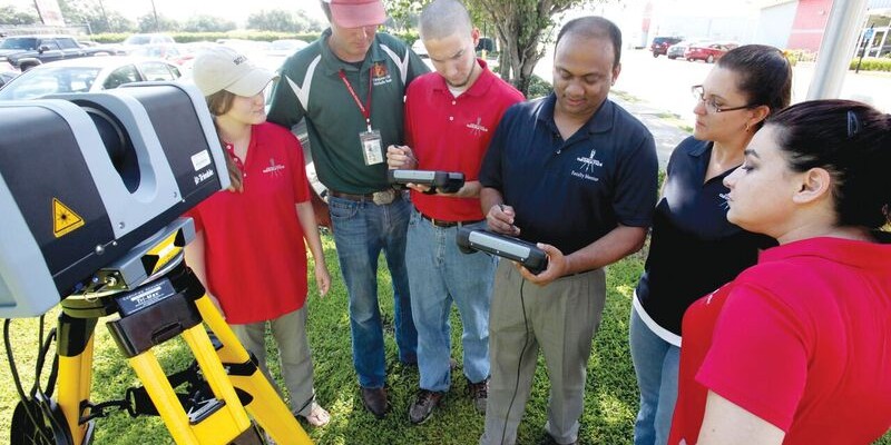
Above: Students receive instructions on laser scanning. L-r: Jessica Freeman, Kent Hebert, Paul LeBlanc, Dr. Balaji Ramachandran, Monica Crout, and Ann Hebert.
Nicholls State University in Thibodaux, Louisiana, initiated its new four-year Bachelor of Science degree program in geomatics during the summer semester of 2003. This program is a result of a process that took more than two years, begun by the Louisiana State Board of Registration for Professional Engineers and Land Surveyors and the Louisiana Society of Professional Surveyors (LSPS).
It was developed by Nicholls State University and approved by the Louisiana State Board of Regents. The geomatics program successfully completed 14 years this past spring semester.
The geomatics program currently has three full-time faculty (one tenured, one on tenure track, and one on non-tenure track), two associate professors, and an instructor. The program meets the educational requirements for registration as a professional land surveyor in Louisiana and the eligibility requirements to take the Surveyor in Training examination. It’s accredited by the Applied Science Accreditation Commission of ABET.

Cody Parks & Paul LeBlanc use an R10 GNSS receiver for a field lab.
Program Nature
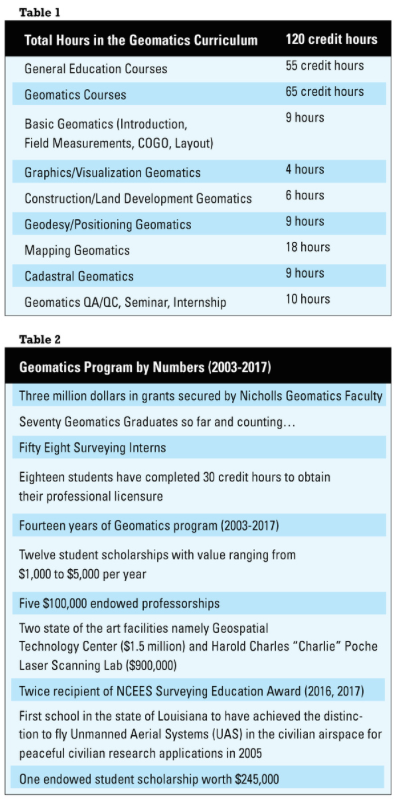
The Nicholls geomatics program is uniquely designed to provide a well-rounded, broad education in the way land form and spatial data are measured, recorded, processed, stored, retrieved, and shared by the use of conventional methods and emerging technologies in GNSS, GIS, terrestrial laser scanning systems, land information systems, and unmanned aerial systems. It will align with the increasing demands by society for more data with increasingly higher standards of accuracy (see Table 1).
The program delivery is mainly through daytime course offerings in the fall and spring semesters. In the first two years of the program’s inception, due to a high number of nontraditional students, courses met in the evenings to facilitate their work schedules. Starting in fall of 2006, the delivery mode of all course offerings was during the daytime to encourage high-school students to enter the program.
In the summer of their junior year, the students are required to complete a mandatory summer internship. A high percentage of students completing summer internships receive job offers in the interned firms after graduation.
 The program also requires students to enroll in a mandatory zero-credit-hour GEOM 104 geomatics service learning course every semester. The students are required to participate in predefined service learning projects/activities, broadly classified into three categories: community, professional, and program.
In a given semester, students are required to complete a minimum of 30 to 45 hours of service-learning activities; the list in each of the categories is provided to the student at the start of the semester. The main goal of this course is to make students better citizens and professionals beyond the educational requirements they met while at school.
Table 2 summarizes the major milestones accomplished since the inception of the program.
Undergraduate Research Experience and Infrastructure
Through the program faculty efforts, LSPS has initiated the Every Member Campaign to raise funds to support our geomatics program. Over the last 14 years the campaign has donated more than $350,000 to the program for discretionary use.
The geomatics faculty has leveraged these funds to secure research and infrastructure grantsworthmorethan$2M. A no-cost annual loan worth more than $155,000 with NEI Inc. and Trimble places five high-precision R-10 GNSS receivers with the faculty.
We have a cooperative agreement with Terrebonne Parish Consolidated Government (TPCG) for research, maintenance, standardization, backup, and analysis of Parish geospatial data by our geomatics students and faculty. The parish datasets are used in most mapping-related courses and senior projects. This exposes students to the ability to access, maintain, store, and analyze real-world datasets in their course assignments and projects.
The agreement was formalized in 2007, and the effort is worth $30,000 per year. The total effort to-date is worth $330,000, which has provided invaluable research experience and on-campus employment for 30 students over the course of the agreement. TPCG benefits from hiring qualified technical personnel from our program for their summer projects, and program faculty conduct research projects that support undergraduate students.
The U.S. Army Corps of Engineers (USACE), New Orleans District, signed its first Memorandum of Agreement (MOA) with Nicholls State University in 2013. The agreement focuses on the advancement of geospatial engineering, engineering, science, and education through technology transfer, knowledge exchange, personnel development, and student mentoring.
We have a commitment from USACE to employ two summer interns from our geomatics program every year. The MOA allows access to USACE research facilities and data collected for use in our courses.
Program Graduates
Our program graduates are well sought after with multiple offers upon graduation. The NCEES Fundamental of Surveying exam passing rates for first-time takers for our program students is around 95%, compared to 55-70% for the national passing rate of first time takers. 83% of our graduates are surveying interns (58/70). Of the remaining 12 graduates, three went through hydrographic surveying certification, four are in mapping or drafting related careers, two are working for government agencies that requires geodetic and hydrographic surveying certification, and two are employed as survey technicians.
For inquiries about the program, visit the website.