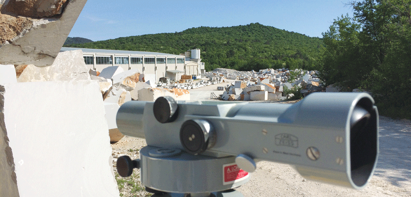
In Slovenia, a team monitored slope stability in an open-pit quarry using a classic, optical precise level and Invar rod.
Editor’s note: Cost-benefit analysis dictates that, for open-pit mines and quarries, steep slopes allow for the most efficient extraction of resources but at an increased risk of slope failures. This adapted paper outlines an example of the analysis of site-specific risks that led a monitoring team to eschew large and complex technological solutions in favor of legacy instrumentation. Sometimes the best tools are “old school.”
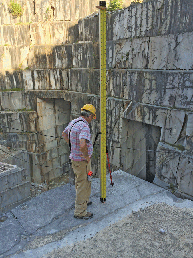
Readings from a 3-meter Invar rod provide controlled precision and help calculate the elevation of rods drilled in the rock.
Before we start a monitoring project, our engineering team is asked many questions by our clients, such as: “Is this necessary? How often should we do it? Which instrument or sensor would be the best? How much can we spend?” The solution we choose for the clients has to be simple, as inexpensive as possible, and reliable enough to prove the quality of data we collect onsite.
Finding the best monitoring solutions is a question not just of investment costs and data quality or quantity, but also of the right method for potential risk elimination, such as suitable ground support or excavation shape adjustment, including the frequency and long-term plan of monitoring.
Accessibility of unstable slopes and the failures of wedges or settled surfaces are part of both inexpensive short-term and costly long-term automated geotechnical monitoring programs. If it’s necessary to investigate deeper into a problem, the project also has to include a potential upgrade of the monitoring system.
Geology and Risks
Rock strength, deformation parameters, and discontinuities play a main role in determining the reinforcement and support requirements in open-pit and underground excavation of hard rock.
Rock mass in quarries is very susceptible to tectonic disruption, which means a high level of risk during underground mining and for the slope stability of an open pit. Groups of cracks that link along the top or side of an excavation can form dangerous rock wedges.
Best practices show that most of the problems in dimensional stone excavation are the consequence of tectonic influence, cracking, and fragmentation. For this project, we were facing typical failures in hard rock excavation such as wedge failure, with two or three intersecting discontinuities or plane failures on one slope because of geometrical conditions and geological discontinuities (cracks).
Cracks are generally empty with water flowing through them, but they sometimes are filled with hard, red clay, which can be found in the Karst (or Kras) region of Slovenia. If ice or other materials expands in the cracks, this increases the risk.
The thickness of clay layers in cracks varies from less than 1mm to less than a centimeter thick. When cracks’ faces are covered with red calcite incrustation, the rock are more unstable; when cracks do not have incrustation, such as when the surface of discontinuity is wavy, the cracks make the rock less stable.
From the spacing between the cracks is determined the GSI (Geological Strength Index). If lower than 50, the rock mass may have irregularities and cracks filled with clay. Geotechnical parameters of limestone found in this quarry, reduced by Hoek analysis, are 50-55. This means that we have rock mass well interlocked, undisturbed, and consisting of cubical blocks formed by three or four intersecting discontinuity joint sets. The surface layer of the rock mass was very poor, very blocky, and disturbed by weather conditions.
Monitoring Method
For the most economical way of detecting displacements of wedges on quarry slopes, we chose the simple method of precise leveling and discontinuity-crack measuring. After we determined the specific geotechnical problems of the location, we bought equipment from a local contractor: a classic optical precise level with a 3m Invar rod.
Our method of leveling was a double run between two stable references outside of the area of suspected movement. First we installed settlement points on locations where the risk of wedge slide was the highest. All points were surveyed twice in two directions between references to yield reliable and precise results after an adjustment of the survey data.
We installed stable reference points, such as drilled anchors in the solid rock, on numerous undisturbed areas around the open pit, yet close enough to the critical locations of the monitoring points to keep the respective legs of level runs as short as possible.
Survey points (bolts in the rock) were drilled 0.5m deep but not through the cracks or joints in the rock. On top of the bolt was welded a domed nut from chrome-plated steel, which offered a highly polished surface to be in touch with the leveling staff.
The geometry of the network of level runs was designed and optimized on at least four stable monitoring points (acting like junctions of links) with overlapping runs through common references.
From the given results it was possible to calculate the probability and reliability of measurements. It is important to provide reliable data to the mining operator, and if the monitored rock mass starts to move, it’s necessary that the methodology provides us with immediate confidence in the data.
Because monitoring was infrequent in this case, it was necessary to act quickly on site after receiving results; this is the reason why the project had to be designed properly and supported with many professionals from different fields such as geotechnics, mining, geology, and surveying. Facing the high costs of survey teams and equipment on the market, it took time to prepare the best solution to offer a satisfactory safety level and accurate geotechnical feedback to engineers.
To provide the best quality data, we needed to organize survey measurements at the right time and with the right weather conditions to avoid climate factors and effects from mining operations in the pit, such as cutting, breaking rocks, and transport of material. All external factors can affect precision of measurements during this kind of work.
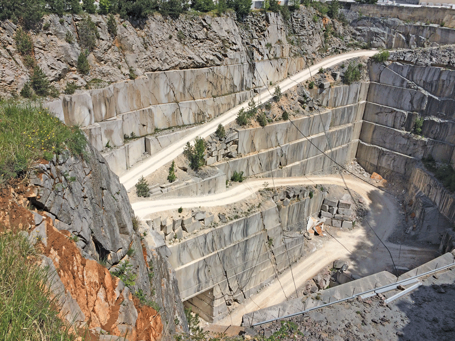
Rock mass in quarries is susceptible to tectonic disruption, which means a high risk level for slope stability.
Survey Equipment
Classical optical precise levels and Invar rods have been in use for many decades and continue to provide precise results far into their work lifetimes. [If properly adjusted and certified, there is no reason that a precise level and Invar rod might not outlast the careers of some of their operators]. We chose for this monitoring project a Carl Zeiss Ni2 level, made in the 1960s, in a factory at Oberkochen, Germany. It’s equipped with parallel plate: a micrometer to measure with submillimeter accuracy.
Shifting away from all the digital technology in use today was challenging for surveyors. It took a few days of practice to find the most effective way to work and to understand all the tricks of a high-precision way of surveying.
The telescope of the instrument has a magnification power of 32 times and an objective diameter of 40mms. It is 270mms in length and produces an upright image. The crosshairs form a straight cross with stadia hairs on the vertical hair. In contrast to most other geodetic instruments, the crosshairs occupy only the central 50% of the field of view. The reticle has stadia hairs with a constant of 100.
The compensator of instrument allows you to level a one-kilometer double run with an accuracy of 0.7mm, while the parallel plate micrometer improves this to 0.3mm/km, which was substantially better than the early pendulum-type instruments. The range of the micrometer is 11mms, more than the typical 10 or 5mms that would become typical in later instruments.
Specially designed staff shift plates had to be made for different types of ground surface, with long and sharpened legs, to provide the best stability and anchoring.
The instrument had been tested to see how temperature, weather conditions, and a different surveyor can effect the results. After calculating collimation error, it was ready to start real work. Readings from the Invar staff were written on a paper spreadsheet for archives and in a tablet computer excel sheet, which provides control precision and calculates elevations of drilled rods in the rock. This is the first feedback to the surveyor on site.
After this, all data were controlled with special care and adjusted with parameters derived from the preceding surveying process.
Results
After five months of measurements, the accuracy of surveyed data is near 0.2mm, also repeatable in varied weather conditions. It is very important to maintain the same high levels of precision to demonstrate stability of the area and to eliminate any concerns of authorities who are supervising mining works and safety in excavation. Safety concerns afford no short cuts.
The quarry contractor can continue all work without any concerns of rock falls and other safety risks in the pit and underground. Investment in monitoring was minimized as much as possible, and it has yielded satisfaction with efficiency.
Conclusion
This example shows how it is possible to get extremely important geotechnical engineering data with simple instruments through an affordable method. As planned from the beginning of the project, the cost of monitoring will be even lower in the future through reduction in frequency, which will be two or three times per year. Work will be timed to coincide with climate changes or important blasting work in the pit (after events that could disturb rock mass in the area). At the moment, the most important task is to show slope stability over the period of a year; this should confirm all predictions in project stability.
Many geotechnical and survey instruments are available on the market, and it is possible to find many reviews of best solutions for whole industry segments but often much more difficult to find direct advice specific to end users’ needs. We do not directly endorse any specific products. Design philosophies and suitability to particular problems dictate the appropriate method and equipment. Users are urged to understand the whole concept of the engineering problem at hand before selecting solutions.
Reference: Kortnik, J. (2009): Optimization of the high safety pillars for the underground excavation of natural stone blocks, Acta geotechnica Slovenica, vol. 2009/1.