Surveying the Gorgon Jetty Project on Barrow Island off Western Australia involved integrating structural, mechanical, and hydrographic surveying technologies and skills.
Barrow Island is described by some as Australia’s answer to the Galapagos Islands. The 202 km2 (78 mi2) island and its surrounding ocean are home to diverse and unique fauna, including marsupials, reptiles, sea mammals, and coral. Due to its isolation, the island offers a rare glimpse into what an untouched Australian continent might have looked like before European colonization. For this reason, the island is classified as a Class A nature reserve.
The Gorgon Project is under construction on Barrow Island, around 60 km (37 mi) off the northwest coast of Western Australia. It’s the largest single-resource development in Australia’s history, including a liquefied natural gas (LNG) facility that’s a three-train, 15.6-million-tonnes-per-annum plant and a domestic gas plant with the capacity to supply 300 terajoules of gas per day to Western Australia.
Subsea infrastructure will transport natural gas from the Gorgon and Jansz-Io fields to the LNG plant on Barrow Island. From there, LNG destined for domestic use will be piped to the mainland; LNG for international markets will be off-loaded from a jetty.
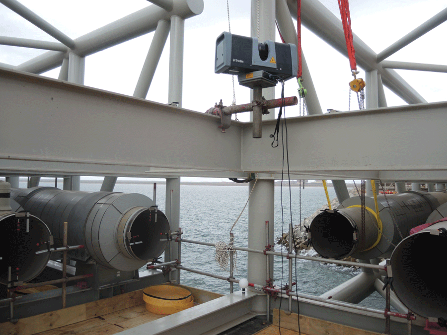
A 3D scanner provided a clean representation of pipe ends.
Gorgon Jetty Construction
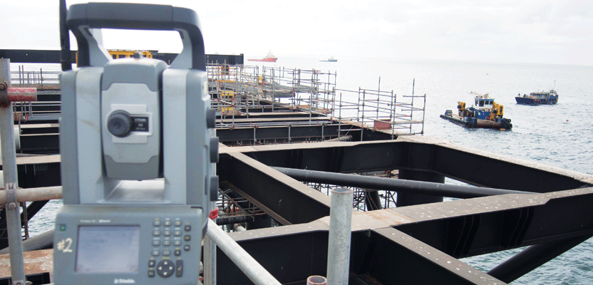
Western Australian firm CADS Survey was contracted to perform surveying for Gorgon’s 2.1 km- (1.3 mi-) long loading jetty, including structural, mechanical, and hydrographic surveys. They also developed and managed the necessary automated module guidance systems.
CADS Survey employs 40 surveyors performing conventional, laser scanning, unmanned aerial vehicles (UAV), and hydrographic surveys, so it was well equipped to meet the tasks and challenges presented during the project. Simon Bush, co-owner of CADS Survey, was the survey manager of the Gorgon jetty project.
Surveying work commenced in earnest with the placement of caissons on the sea floor. These round, concrete shells were then filled with heavy gravel to function as piles for marine structures such as bridges and jetties. The use of caissons protected Barrow Island wildlife from the disruption caused by traditional percussion piling.
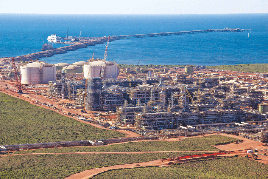
The Gorgon Project is operated by an Australian subsidiary of Chevron and includes construction of an LNG plant on Barrow Island.
Screed was used to form a level base for the caissons. During the screeding process, a GNSS modular receiver and a modular add-on GNSS receiver were attached to the crane hook, barge, and screed frame to provide guidance. The crew used Trimble HYDROpro marine construction software to visualize the process as screed frames were accurately positioned and leveled. Dips and ridges detected by the hydro vessel used by CADS were postprocessed on the control barge, and the results were reported back before the frame’s positioning was signed off.
Although this process took approximately two hours, the time delay was inconsequential. Bush said, “It takes hours to move a barge, because each one has four to six anchors to keep it steady. So real-time feedback wasn’t required for this phase.”
The survey vessel was again used to verify that the extents and elevations of the gravel beds were satisfactory once screeding was complete.
Caisson Placement and Stabilizing
For accurate caisson placement, the upper beam of each caisson was mounted with three to four GNSS receivers, which wirelessly transmitted position data to the HYDROpro software. In the control room, located on the caisson floating barge, an operator could clearly see on-screen the position and tilt of the caisson in relation to the design location.
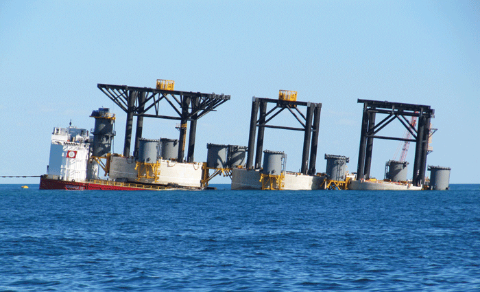
Caissons being floated off a semi-submersible barge.
A team that included engineers to determine how much water to pump into the caisson to keep it level, a hydrographic surveyor, and a winch operator watched the visualization on three large screens. HYDROpro displayed winch lines to help the operator determine which one to use to move the caisson, plus information such as vertical-distance-to-touchdown and caisson center location. The latter screen was used when the caisson was close to design location.
Integrated Surveying
To solve the problem of poor network geometry for total station observations, CADS Survey observed primary control points with static GNSS—these tied back to the high-order network on Barrow Island. The baselines were observed for 12 hours or more to negate any subtle movements caused by environmental factors.
Said Bush, “Caissons sway so you can wander off with your traverses. The static GNSS tied everything back to the Barrow Island network. It was an insurance against angular drift in the total station traverse.”
Caissons were placed 80 m (260 ft) apart. At approximately every 500 m (1,600 ft) survey pillars were installed on a caisson. Further static GNSS baselines were observed to each one.
CADS Survey’s Hydro Vessel
For much of their hydrographic surveying, CADS Survey relied on a survey vessel equipped with echo sounders, a motion reference unit, a gyro, and an RTK GNSS system.
The R2Sonic multibeam echo sounder was well suited to shallow water; the Ceestar single beam provided quality control for the multibeam system. The TSS DMS-05 motion reference unit measured sea rotation and acceleration to give correction values for heave, pitch, and roll. The RTK GNSS system, a Trimble SPS852, used CADS Survey’s GNSS base station setup at the LNG plant construction site to deliver centimeter-accurate 3D positions.
All of these navigational aids enabled the vessel to return results accurate to approximately 50 mm (2 in) in calm or moderate seas.
Achieving Level Accuracy
In strategizing how to ensure that both ends of the jetty met in the middle, CADS Survey decided to try long-range reciprocal trigonometric heighting. The team set up two total stations to face each other from neighboring caissons and observed from both ends of the line. They measured at exactly the same time to derive mean elevation differences while minimizing the effects of refractive turbulence.
Solving Access Problems with 3D Scanning
When pipe modules were installed, they came with straight lengths of pipes already installed. CADS Survey’s next task was to deliver accurate pipe end measurements.
Rope access climbers, with sea beneath them, bolted the 3D scanner in place close to pipe racks. The survey team positioned themselves nearby with the scanning PC running Trimble RealWorks software. The high-precision instrument provided a clean representation of pipe ends that they could model with certainty.
On the Gorgon Jetty Project, the CADS Survey team greatly enlarged its toolbox of surveying capabilities and technology. Bush concludes, “The LNG jetty and construction sequence was not a traditional land-to-jetty-end build, so it provided a great surveying challenge. To maintain high accuracy in the build, we really had to use the latest surveying technology available.”