
Lush vegetation, beautiful ocean vistas, and a historic Hawaiian valley provide the setting for a complex engineering project that addresses technical and cultural concerns.
The Waipio Valley on the island of Hawaii has great historical significance within Hawaiian culture. Known as the Valley of Kings, it was home to many generations of the royal family and is considered sacred by native Hawaiians.
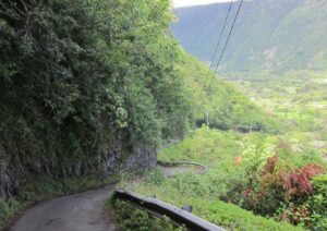
Overhanging vegetation lines the narrow, steep road descending to the valley. Courtesy Haley & Aldrich.
Traditional taro farming still takes place in the fertile valley, and it is a popular tourist attraction, thanks to the black-sand beach, waterfalls, and spectacular views. Access is limited to a one-lane road that was originally a donkey trail/foot path not suitable for today’s heavy traffic. In 2020, Hawaii County initiated a geologic engineering evaluation of the Waipio Valley Road to provide options for addressing ongoing safety concerns and maintenance issues.
High Risk Terrain
The Waipio Valley Road is narrow and winds along the steep hillside of the south valley wall, with approximately 800 feet of elevation change in just 0.7 miles, resulting in as much as a 40 percent road grade. Farmers, fishermen, Hawaii residents, and tourists all use this road to access the valley floor, either by four-wheel drive vehicles or on foot. With up to 450 cars and several hundred hikers traveling to the valley floor on busy days, amid worsening roadway conditions, the possibility of accident and injury was growing.
“Environmental factors impact our work all over the islands. In addition to volcanic activity, climate change is causing an increase in the intensity and duration of storms, which leads to more flooding, rockfalls, slope failures, and washouts,” said Janice Marsters, Haley & Aldrich senior principal, Hawaii. “Topography in Hawaii includes deep gulches and steep walls that make it difficult to maintain bridges, roads, and utility lines.”
A slope failure in March 2019 damaged the Waipio Valley Road, leading to a temporary closure and creating a hardship for farmers, fishermen, and others who needed access to the valley floor.
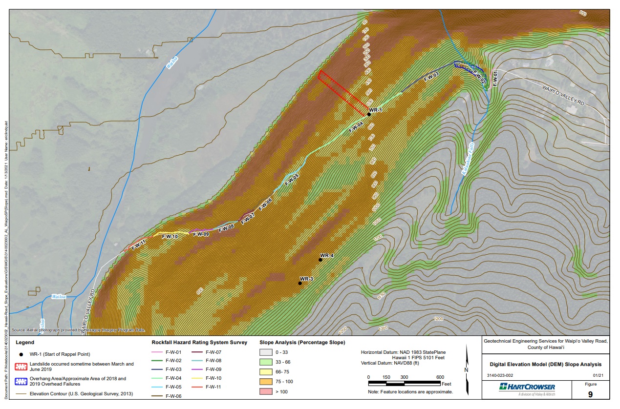
The county recognized there was a public safety issue and contracted with Haley & Aldrich to perform a preliminary geotechnical engineering study of hazards along the roadway, summarized in a report released in January 2022. The initial evaluation included rappelling along the steep valley walls to gather data for topographic maps, soils mapping, rockfall hazards, and roadway instability.
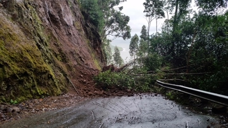
A soil landslide and uphill tree debris blocked Waipio Valley Road after heavy rains in 2018. Courtesy County of Hawaii Civil Defense Agency.
“The road is extremely steep and narrow, with unstable embankments on the upslope side of the road and steep drop-offs to the ocean on the other side,” said Steve Pause, Hawaii County public works director. “The road or trail as originally constructed is particularly susceptible to slope failure, washouts, and rockfalls, especially under severe rainfall events.
“While not feasible to close the road until all necessary repairs can be completed, as this is the sole access to the valley for farmers and residents, we have had to take steps to reduce risk of injury by limiting vehicular access to the road and preventing pedestrians from using the road.”
Surveying on a Rope
The thick vegetation, unstable rocks, and vertical cliffs in the Waipio Valley offered a unique challenge to the Haley & Aldrich survey team.
To prepare their assessment, Haley & Aldrich used regional geologic and topographic maps, USGS 10-foot contour lidar data, field reconnaissance work, and slope rappel traverses above and below Waipio Valley Road. Climbers carried geologic compasses, range finders, and Trimble handheld GPS receivers to capture transect data.
The transects were overlaid on topographic maps to provide a standardized grid for field observations. The lidar helped determine topography and slope gradients.
The rappelling team consisted of three SPRAT (Society of Professional Rope Access Technicians) certified climbers and three safety crew members on the ground. GPS satellite connectivity was spotty due to tall trees on the slopes, and maneuvering through heavy vegetation carrying the equipment created additional challenges. Several correcting RTK base stations helped reach one- to two-foot accuracy, and known features like telephone poles were used as reference points for further verification.
“This project provides a unique look at geologic hazards. In Hawaii, volcanic flows make up the bedrock, which is weathering into saprolite. Saprolite acts in some ways like a soil and in others like a rock. Our short-term goal is to get down to stable rock to reduce the chance of rockfalls and slides, but the rock is continuously changing,” said Chris Eddy, Haley & Aldrich engineering geologist. “Our industry used to take a reactive approach by fixing problems after they occurred, but now we’re becoming proactive by developing long-term asset management plans that help mitigate problems before they arise.”
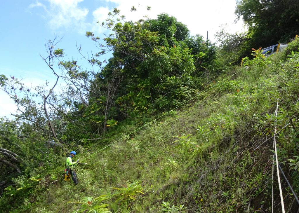
SPRAT-certified climbers carried survey equipment to capture transect data above the road. Courtesy Haley & Aldrich.
The preliminary report released in January 2022 included analysis based on industry-accepted modeling tools applied to the available data. Number scores were used to estimate rockfall hazards, roadway instability, and risk to vehicles and people. Based on this information, Haley & Aldrich proposed different methods for mitigating risks to the roadway and estimated associated relative costs.
As a next step in providing more detail about individual features and a more robust delineation of hazard types, new drone lidar data were flown in May 2022 and plotted in two-foot contours about 100 feet above and below the road. The physical locations of upslope and downslope geologic hazards were captured using a GPS device and mapped for future reference.
“Based on further site reconnaissance, our second report focused on prioritizing hazards by risk level and grouping work by complexity,” said Dan Trisler, principal geotechnical engineer at Haley & Aldrich. “To improve safety for everyone, we’re balancing the residents’ need for access to the valley with the technical challenges of mitigating rockfalls and landslides on a very steep and narrow road.”
Effective Long-term Planning
Haley & Aldrich shared results of the studies at a community forum in October 2022. Along with high-resolution photographs and topo line maps, the team presented mitigation options and timelines and answered questions from attendees representing different interest groups.
The county decided to pursue a phased approach to implement improvements. Phase one addressed removal of the highest priority vegetation and loose soil and rock along the upper, more accessible, portion of the road, where failure of these overhanging hazards was an urgent concern.
Biological and archaeological surveys were conducted to ensure no sensitive resources were damaged by the work. After additional engineering design work, later project phases will include road improvements, such as new pull-outs and better drainage to prevent uncontrolled surface water running over the road. Other logistical enhancements to reduce traffic are also being evaluated, such as shuttle buses and a reservation system.
“A committee was already discussing safety issues and options before the study began, but it was important to have an accurate assessment of the risks before coming to any conclusions,” said Heather Kimball, a member of the Hawaii County Council. “Our goal is to develop a long-term management plan that takes into consideration the interests of many groups. It is important for us to provide safe organized access to visitors and residents while respecting the cultural and historical significance of the area.”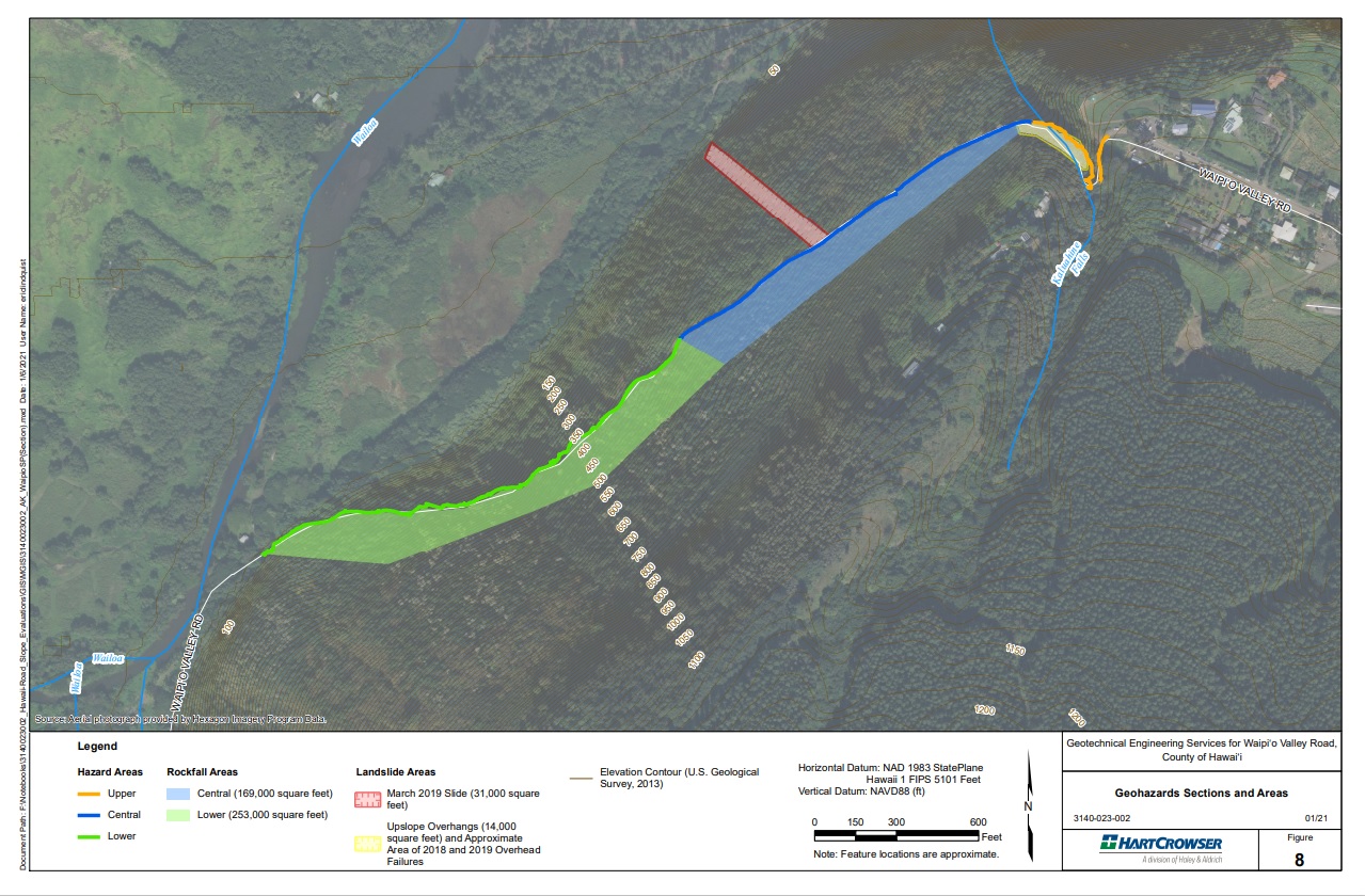
PDF Pages from Waipio_Geotechnical Engineering Evaluation