Tag Archives: 3d models
Rapidly Mapping Infrastructure
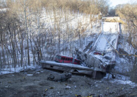
Could a Pittsburgh-based start-up help improve (and save) America’s bridges? Early in the morning of January 28, 2022, a Pittsburgh Regional Transit Authority bus crossing the Fern Hollow Bridge began bouncing and shaking for no apparent reason. Moments later it plummeted into a ravine along with several other vehicles as the bridge collapsed beneath them....

Sounds Good
Using powerful simulation algorithms, this young and award-winning acoustics software startup from Iceland is making sound visible. No wonder it’s already creating a buzz in the BIM community. For Finnur Pind and Jesper Pedersen, success started inside a dark and windowless basement. Backed by a research grant in 2020 and a free room down in...
3D Models Above and Below
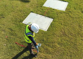
Aerial, terrestrial, and underground data tell the whole story Millions of miles of underground utilities provide U.S. communities with vital services, such as telecommunications, water, electricity, and natural gas. During construction projects, accidental damage occurs frequently due to inaccurate or non-existent documentation, a situation that can be exacerbated by inadequate research before excavation begins. Safety...
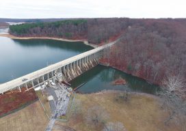
A Dam Good Mix
Above: A view of the Brighton Dam in Brookeville, Maryland, from one of the project’s UAVs. Combining UAVs and 3D computer vision can make infrastructure inspections cost-effective. More than 70% of the 90,000 dams scattered across the U.S. are, according to the American Society of Civil Engineers (ASCE), half a century old. The age of dams,...

Drone Art: Art Meets the Science of UAS at Elevated Element
Our company, Elevated Element, uses UAS for aerial photography. Our monuments capture project came about when we were contacted by Direct Dimensions, a 3D modeling firm, with the idea of combining the techniques of aerial UAS photography and digital 3D scanning. We chose the Francis Scott Key Monument in Baltimore’s neighborhood of Bolton Hill because...