Tag Archives: 3d scanning

Early 3D Scanning Competition: 1998 – 2000, Part 13
When you join a start-up, as I did in 1998 with 3D laser scanning pioneer Cyra Technologies, you worry about two things. One is if your start-up’s “new thing” will catch on in the market and your company will survive. The second is if a competitor will “out-invent” you with something better (and your company...
The Early Days of 3D Scanning: Part 12
In this article, I’ll describe the early user community as Leica was in the process of entering the 3D scanning products business. Although most users at the time were struggling, there were some well-publicized breakthrough user successes that reinforced their belief in the technology’s upside.

Everything you ever wanted to know about Mobile Mapping
Explaining the tools and technology behind mobile mapping devices for experienced laser scanning professionals looking to make the jump to this new technology. In its short life, the market for 3D as-built documentation technology has seen considerable innovation. Among the myriad new tools to hit this market, nothing has changed the way we capture buildings...
Handheld vs terrestrial lidar for building documentation
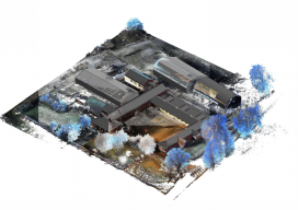
Sponsored by Paracosm Above: nmcn’s final CAD model as generated from PX-80 data. The 3D model is situated in the topographical point cloud data. Are these new tools accurate enough? Handheld mobile lidar scanners have gained market share in recent years by offering faster capture in GPS-denied indoor environments, easier documentation workflows for large, complex spaces,...

How SLAM scanning helps AkitaBox make FM a no-brainer for its customers
Sponsored How handheld 3D scanning enabled one company to capture large assets with unprecedented efficiency Like many new 3D technologies, AkitaBox’s facility management (FM) software was born when someone started asking questions about the accepted way of doing things. When co-founder Josh Lowe explains the genesis of AkitaBox, he talks about how he used to...
GeoDude: The Adoption Status of Laser Scanning Today, Part 1
By Geoffrey Jacobs Note from the editor in chief: In 2006 when I began at this magazine’s predecessor, Professional Surveyor, Geoff Jacobs was already an established 3D scanning columnist, trusted as an industry specialist and read regularly by our subscribers. He’s a significant leader in the field; Geoff is also a pleasure to work with....