Tag Archives: Leica
xyHt March 2016 issue
Click here to view the March 2016 issue of xyHt magazine.
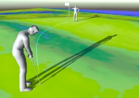
Golf Simulator: Unlocking the Mysteries of the Green
A new hyper-real golf simulator app developed with point clouds calibrates golf greens so golfers can raise their mental game. Every golfer knows, you “drive for show put for dough.” Yet, once the ball is within several yards of the hole, it seems to take on a mind of its own. It speeds up, slows...

xyHt News Links: 11/13/15
EngineerSupply Ranks in the Top 300 of B2B Maps go 3D thanks to machine vision Lockheed Martin Advances Threat Protection on GPS Control Segment Spirent Issues Ebook on Testing Drones, UAVs Ebook: An Introduction to Testing Navigation and Positioning Performance in Drones, UAS and UAVs. Vricon introduces groundbreaking medium-resolution digital surface model The Geological Society...

Autodesk + Leica Geosystems
Two tech giants embark on a collaboration and education outreach. At June 2015’s HxGN LIVE (the annual user conference for Leica Geosystems and other divisions of Hexagon), we spied something rather surprising: an Autodesk booth. What’s more, someone at the booth was using Autodesk software for construction layout on a consumer tablet, driving a Leica...