Tag Archives: Leica
GNSS in Construction
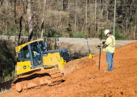
Above: Using GNSS networks in construction saves time and reduces the potential for errors. Credit: Leica Geosystems. Forward-thinking contractors are signing up for network subscriptions in record numbers as the benefits become more widely understood. By David Rowlett John Hugerich still remembers using a base station and setting up a local network for every stockpile...

xyHt Industry News Links: 2/17/17
3W-International – Demand for combustion engines for unmanned helicopters Orbit GT releases Oblique Mapping and Feature Extraction v17 SimActive Unveils New Licensing Options Prototype for “native LAS 1.4 extension” of LASzip LiDAR Compressor Released Verifly Increases Coverage Areas, Ups Limits and Time Periods New Global 4K High-Speed Camera for Science, Aerospace and Defense Industries Pitney...
xyHt News Links: 8/12/16
iSTAR 360 degree Measurement Module integrated by imaging companies Australia drifts away from GNSS measurements VGI in Land Administration: A Vision or a Necessity? A New Era in Land Administration Emerges The New State of Smart Cities: Analytics + 3D Visualization as a SaaS Esri and Leica partner to offer GIS/GPS grants to governments Strong...
xyHt News Links: 6/17/16
Hexagon launches HxGN SMART Build, a pioneering enterprise construction management software solution Milrem and Leica Geosystems Announce Pegasus:Multiscope: A New Unmanned Ground Vehicle for Surveying, Security, and Monitoring Applications FAA issues GPS interference flight advisory Gamma 2 Robotics Launches Fully Autonomous Security Robot, Partners with Hexagon Safety & Infrastructure Leica Geosystems announces world’s first fused...
xyHt News Links: 4/22/16
3D Robotics Announces Transformative New Software for the Solo Smart Drone Platform Topcon and RDO announce expansion to GNSS network service Trimble Announces Call for Speakers for its 2016 Dimensions User Conference Introduction of complete propulsion systems at Xponential 2016 Investigation launched over possible UAV/airplane collision Leica Geosystems launches smart antenna with superior performance DJI Unveils...
xyHt News Links: 4/15/16
New Autonomous Airborne Mapping Solution Redefines Industry Expectations Surphaser introduces a new 3D scanner and high precision mobile mapping system SurphSLAM Maptek releases Vulcan 10 and Maptek Workbench MAVinci SIRIUS UAS Surrey Satellite and BridgeSat to Develop Free-Space Satellite Optical Communications Solution Topcon announces global distribution agreement with VMT GmbH Carlson Software Releases Carlson SurvCE...