Tag Archives: mapping

xyHt Weekly News Recap: 09/30/2022
Teledyne and Seabed 2030 to Study Impacts of Volcanic Eruption in Tonga Greater St. Louis, Inc. Wins Esri Special Achievement in GIS Award Bluesky Takes to the Skies to Capture More Oblique Views of UK Cities Bentley, Genesys to Provide 3D Mapping Capabilities for Cities across India Free Webinar: What’s the Latest in Survey and...
Staying Fluid: The Ocean Decade
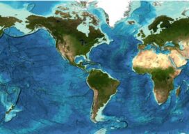
More than 23 percent of the ocean seabed is now mapped Seabed 2030 is a partnership between the Nippon Foundation and the General Bathymetric Chart of the Oceans (GEBCO) and aims to map the entire planet’s seabed by 2030. To date, the project has mapped around 23.4 percent of the seabed. The latest data was...

Upgrading GIS for a Better 911
The complex system of emergency call routing and critical location data delivery is getting a makeover Minutes can make a difference between life and death for 911 callers. A quick response with suitable equipment and knowledgeable personnel is the goal of 911 call centers across the country. However, managing calls and texts from mobile phones...
xyHt Weekly News Recap: 06/17/2022
IMAGINiT Develops Additional Time-Saving Utilities for Autodesk Revit Surveying Shallow Water from Space Trimble Introduces OEM GNSS Receiver Module for Industrial Autonomy Applications Geo Connect Asia 2022 Hosts Close to 2,000 Professionals from 36 Countries Drone Nerds Introduces Advanced Mapping and Surveying Solution, the ViDoc RTK Rover Expedition to Deepest Point on Earth Will Collect...
xyHt Weekly News Recap: 06/10/2022
IMAGINiT Develops Additional Time-Saving Utilities for Autodesk Revit Surveying Shallow Water from Space Trimble Introduces OEM GNSS Receiver Module for Industrial Autonomy Applications Geo Connect Asia 2022 Hosts Close to 2,000 Professionals from 36 Countries Drone Nerds Introduces Advanced Mapping and Surveying Solution, the ViDoc RTK Rover Expedition to Deepest Point on Earth Will Collect...
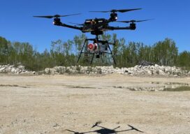
Fusing Aerial and Mobile Lidar Data
Creating accurate as-builts of a complex facilities is no longer a long-term project. When the Caltech Group was founded by two men in Calgary, Alberta, in 1990, they set out with the goal of becoming Western Canada’s go-to company for geomatics services with an eye on specializing in the oil, gas, and utility areas—those companies...