Tag Archives: surveying

What’s the Buzz?
While I was employed at Rettew Associates, Inc. in the late 1990s, I worked with a great survey technician by the name of Craig West. Craig and I got the opportunity to work together on a big boundary survey for the National Park Service along the Appalachian Trail in Maryland. The boss sent me because...
Reasons Not to Apportion Subdivision Lots
Apportioning excess or deficiency in platted lots seems like a quick and painless solution to a problem subdivision retracement when original corner marks are not immediately apparent.
Generation S(urveyor)?
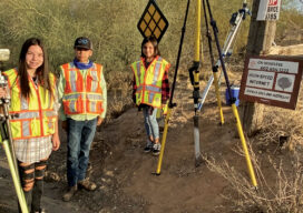
A surveyor’s children are introduced to the ancient craft with real, hands-on experience

Remote Sensing – It’s About the Safety
If you follow trends in industry that serve our profession, it is impossible to not see articles and advertisements about the use of remote sensing technology. Unmanned Aerial Systems (UAS/drones) tend to be the leaders of the pack for many reasons. However, there are several others, from stationary and mobile terrestrial lidar scanners and cameras,...

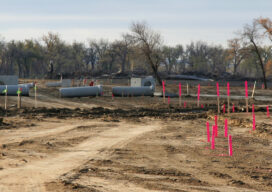
GNSS Innovation Keeps Utility Surveyors Safer
The ability to capture accurate points from a distance with images provides a significant leap in safety and efficiency for subsurface utility engineering.

xyHt Magazine Digital Edition: August 2021
xyHt's August issue features Global Navigation Satellite Systems and their impact on surveyors and geospatial professionals.