Tag Archives: surveying

The Oddities of a State Border
The oddity on the map of the Middle Atlantic states on the U.S. eastern seaboard goes unnoticed by almost everyone—except surveyors and cartographers. In almost every other instance where a river divides two states, the state border demarcation line is the geographic center of the river. But the Potomac River has—since the English charters that...

Policing the Profession
In my last column we touched on the idea of “unchecked incompetent practice” and how that is a problem for the land surveying profession. This time around we are going to dive a little deeper with that idea. In a 1969 article entitle “The Professional Status of Land Surveyors,” Curtis Brown wrote, “professional liability is...
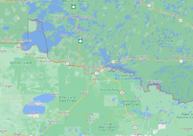
An Awkward Angle
It’s a question that has bothered me since grade school geography. Why does Minnesota have that little protrusion popping out of its northern border? It’s like the state is wearing one of those little red clown hats held on by an elastic strap. I’m several decades past grade schools, but the other afternoon I was...

Is Customer Education Worth It?
The most popular question I’ve been getting via phone and email recently comes in a few different formats, but the meaning is usually the same. “What is the average cost of a survey?” “How much does a survey cost?” And, my favorite incarnation: “I’ve been told by a trusted source that I spent too much...

xyHt Magazine Digital Edition: December 2021
Like a good surveyor, xyHt‘s December issue covers a lot of ground. This month we bring you stories about surveying, lidar, legal issues and an in-depth look at the emerging post-processing kinematic technology. As always, if you don’t have a subscription to our print edition, or if someone else in the office has snaffled your copy,...

xyHt Weekly News Recap: 11/19/2021
NSPS 21st Annual Student Competition Bushfire Mitigation through Machine Learning with AusNet and AWS Register for 11th Utility Investigation School in Golden, Colorado Young Surveyors Network to Meet Dec. 4 Fugro to Update Cayman Islands Hydrography for UKHO with Carbon-Neutral Survey Scan to BIM In Minutes Webinar on Nov. 30 Global Navigation Satellite Systems Market Expected to Grow 8.2% During...