Tag Archives: surveying
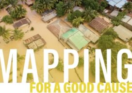
Mapping for a Good Cause
When humanitarian emergencies strike, these volunteers are ready to share their geospatial skills and help communities map their way out of crisis. You, too, can lend a hand. After Cyclone Idai made landfall in Mozambique in the middle of March 2019, it left behind more than 1,000 casualties, miles of damaged roads, and ruined at...

xyHt Weekly News Recap: 11/17/2023
Insights into Lidar Technology and Lidar-Based Surveying Esri Introduces ArcGIS Video Server, Brings New Video Capabilities to Users EU fine-tunes plan to launch Galileo satellites on SpaceX Elevating Belgium’s Railways with Topcon Positioning Systems Esri Integrates with Microsoft Fabric to Deliver Leading Spatial Analytics Capabilities Esri and National Geographic Society Launch National Geographic MapMaker

What’s Inside Your GNSS Rover? Part 3
The third and final installment of a look at the inner workings of high-precision surveying rovers. In parts one and two, which appeared in the two previous issues, we focused on antennas, amplification, housing, channels, boards, and gates. This installment continues with signal matching, positioning engines, and additional components. Matching Signals To distill the observed...
Get Kids Into Survey
We are once again proud to support Get Kids Into Survey to print and distribute their most recent poster. Click the image below to enlarge.
xyHt Weekly News Recap: 11/10/2023
UP42 and GLOBHE Sign Partnership to Bring Drone Data to Geospatial Marketplace Geo Week Announces Sneak Peek of 2024 Keynote Lineup Trimble Partners with HALO Trust for Landmine Clearance in Ukraine Trimble and Skydio Integrate Technologies to Deliver Insights to Construction, Utilities and State Transportation Agencies Geo Week Announces 2024 Conference Program, 200+ Speakers and...
xyHt Weekly News Recap: 11/3/2023
AGI GeoCom 2023 Conference set for London in December TCarta Delivers Satellite-derived Bathymetry for U.S. Coastal Mapping Pilot Swift Navigation Adds Unicore to Partner Program Enabling Broader Use of Precise Positioning Technologies Nearmap PropertyVision Makes Industry Data More Accessible to Insurance Carriers GeoWeek 2024 Announces Conference Program Fullerton College Receives First National Science Foundation Grant...