Tag Archives: surveying

Why Opus Projects? Part 2 of 2
OPUS Projects Streamlines Submitting GPS Surveys to National Geodetic Survey By Philippe Hensel with Dan Gillins, Dan Martin and Julie Prusky “Texas Special Reference Center (TSRC) of Conrad Blucher Institute is leading the efforts toward modernization of the horizontal and vertical datums in the State of Texas, particularly in the subsidence zone in southeast Texas....

xyHt Weekly News Recap: 10/20/2023
Trimble Donates $100,000 to World Food Program USA’s Erase Children’s Hunger Campaign Impressions of INTERGEO 2023 Hexagon expands TerraStar-X GNSS correction service to South Korea Geo Week 2024: Where Innovation and Transformation Converge Alfred State wins NCEES Surveying Education Award Trimble Opens Two Technology Labs at The Ohio State University to Advance the Next Generation...

A New Perspective with Drone Photogrammetry
Geotechnical engineers say drones offer a safer, faster method of data collection to identify potential geohazards and assist with mitigation along vulnerable transportation corridors. Mountain roadways are prime locations for geohazards, such as rockfalls, landslides, and debris flows. These events result in road closures, injuries, and property damage, sometimes triggered by thaw/freeze cycles or...
xyHt Weekly News Recap: 10/13/2023
SOCOTEC’s European Projects to Benefit from Topcon Monitoring Technology CNH Completes Purchase of Hemisphere GNSS CentralSquare Technologies and DATAMARK Partner to Enhance GIS Data Mapping for Emergency Response Bringing Geospatial Context to the Metaverse: Considerations for the Next Steps Bluesky Aerial Maps Improve Efficiency for Forest Surveys Trimble Monitoring Software Expands Sensor Support for Broader...

The Complex Issue of AI and GIS
Part 1 We attended remotely the ESRI User’s Conference (UC) held in San Diego on July 10th and, for the first time, saw and heard how the leading commercial GIS software company in the world positioned itself for the use of AI in its products. It is reasonable to assume that AI can make GIS...
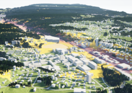
Virtual Reality and City Planning
Engaging citizens to participate actively in urban development projects can often be difficult. But rendering designs in 3D city models and transforming them into immersive virtual reality spaces might just do the trick. When it comes to reshaping cities and constructing new structures, modern architects consider public participation an essential part of creating sustainable and...