Tag Archives: topcon

The Extended Entity of Autodesk
Has Autodesk become too large? Too diverse? Did the software get too complex? Or are those concerns missing the point? We’re far from the day when we can think of something we’d like and it simply materializes: there’s still a long path between ideation and realization. But, for more than three decades the path between...

xyHt News Links: 11/06/15
Esri Collaborates with Microsoft to Incorporate Location Services and Spatial Analytics NovAtel to Develop WAAS G-III—Galileo Reference Receiver for FAA Satlab Offers Hydrographic Echo Sounder for GNSS Rover Hexagon Takes Top Honors in the Wichmann Innovations Award Topcon Offers Control Box for Excavator Systems Lead Air, Inc. releases the MIDAR-H

The Digital Site
The complete digital site is more than just machine-controlled heavy equipment. Recent advances in heavy civil have been profound in connectivity, automation, and visualization. How long has automation played a role in heavy civil construction? As far back as the late 1980s when early GPS-guided (or informed) systems began to reach the market. But it...
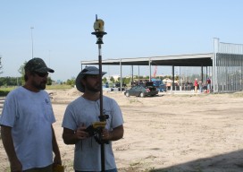
Software Review: Topcon MAGNET v2.0
Topcon Positioning Group has recently released version 2.0 of its MAGNET system. For those readers who are not yet versed in the field-to-finish approach that is MAGNET, prepare to be excited. If the word “cloud” scares you, don’t worry: there is a vast misconception surrounding what the cloud really is, and I will explain some...
GNSS Antennas that Protect and Observe
Editor’s note: Public awareness of the potential for interference and jamming has rightfully increased over the past few years; due partially to at least one high profile incident each of “trucker jammers,” news of battlefield jamming, the jamming event along the North Korean border, and an inadvertent interference instance of naval origin in San Diego....
Going Smaller to Grow Bigger
Editor’s note: Some of the more significant changes in workflows and data management in surveying field and office operations have come in recent years: a move to mobile, robotics, and cloud-enabled software suites. But, how has implementation played out? We offer the following case study of a forward-thinking surveying and mapping firm that has implemented...