Tag Archives: uav

Weekly xyHt News Links: 3/24/17
GEO Business 2017 Launch Cutting Edge Workshop Program SimActive and Tianlifa Launch Integrated UAV Solution WEBINAR | How To Take Aerial Surveying To The Next Level With NEXUS SBG Systems to announce a new generation of the Ekinox Series of inertial sensors. Introducing Polaris — Next-Generation Terrestrial Laser Scanner West Virginia Implements Drone Legislation Senate...
xyHt Magazine March 2017 Issue
Click here to view the March 2017 issue of xyHt magazine.
xyHt News Links: 3/3/17
Orbit GT and RIEGL strengthen data interoperability DJI Introduces M200 Series Drones Built For Enterprise Solutions Topcon announces enhanced integration of GT series total stations with Autodesk MDA to Acquire DigitalGlobe, Creating Industry Leader in End-to-End Space Systems, Earth Imagery and Geospatial Solutions Crane Camera Site Surveying: An Alternative to UAVs?
Drone design: What Goes into Designing a Drone?
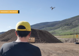
A UAS firm tackles a topographic mission at 10,000 feet above sea level with their own system. (Above: IST Aerial’s Bo LeRoy uses the firm’s DJI Inspire One to collect data for volumetric calculations for compost piles located on a landfill in Colorado.) IST Aerial is a division of Integrated Science and Technology (IST), founded 25...
xyHt News Links: 10/21/16
Teledyne Optech announces new efficiency enhancement for ALTM™ Galaxy wide-area lidar mapping sensor Canon Launches the Océ PlotWave 550 Print System Designed to Greatly Enhance Large Format Technical Document Management AVEVA and AEGEX partner to deliver Digital Asset solutions in Hazardous Environments Rwanda Launches World’s First National Drone Delivery Service Powered by Zipline UAV Drones...
Don’t Drone On: Drone Talk & Geospatial Professionals
How to explain the value of UAS to geospatial professionals. I’m the business development director at microdrones, where one of my goals is to help customers–who sell services like aerial mapping, surveying, infrastructure inspection, and monitoring precision agriculture–communicate to their potential clients the value of using UAS. This can be tricky in such a high-tech...