Tag Archives: uav

From Nadir to Oblique
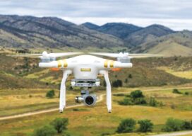
Spic-and-Span Bridges Inspecting the world’s iconic bridges is becoming a UAV job When it was time last year to inspect the Sydney Harbour Bridge, the steel arc structure that spans the harbor of Australia’s capital, authorities Down Under turned to the latest technology available: drones. “The sky’s the limit when it comes to this technology....
Safety is Paramount in Aerial Drone Mapping
As the Federal Aviation Administration (FAA) prepares to release its ruling covering uncrewed aircraft flights beyond visual line of sight (BVLOS) in the National Airspace (NAS) the entire industry is holding its breath preparing for a new era of certainty and expansion. Aerial photogrammetry will be one of the immediate beneficiaries of this new policy...

xyHt Weekly News Recap: 02/24/2023
2023 NSPS Day on the Hill FIG Working Week in Orlando Registration URISA Exemplary Systems in Government Awards Open NV5 to Support Statewide Imagery for Kentucky Geo Business 2023 Registration Open Three Innovative Solutions Selected in “Pitch the Press” at Geo Week 2023 Commercial UAV Expo Call for Presenters EagleView Revolutionizes Asset Management with AI-Based...

Disruptive Lidar Tech
Technologies developed for autonomy and consumer applications are opening up new user segments and rewriting conventional workflows A construction inspector sweeps their phone over an open trench creating a 3D as-built of the utilities within. This is just one example of low-cost, rapid, simplified reality capture is challenging conventional wisdom on how reality capture should...

xyHt Digital Magazine: February 2023
xyHt’s February issue takes a look at what might be in store for geospatial professionals in the coming year. With an uncertain economy, where are the opportunities for industry professionals. As always, if you don’t have a subscription to our print edition, or if someone else in the office has snaffled your copy, don’t fret,...

Ready, Re-set, Go
Post-pandemic digital transformation was on everyone’s mind at INTERGEO. With its mojo back, the world’s biggest geospatial trade event can once again offer the best geo-business innovations to get you all set for 2023. Germany’s annual INTERGEO event is the CES of the geospatial industry. If its Las Vegas counterpart is high on consumer electronics,...