

Spic-and-Span Bridges
Inspecting the world’s iconic bridges is becoming a UAV job
When it was time last year to inspect the Sydney Harbour Bridge, the steel arc structure that spans the harbor of Australia’s capital, authorities Down Under turned to the latest technology available: drones.
“The sky’s the limit when it comes to this technology. It is a game-changer for our preventative maintenance inspections which would normally take months to complete, but can now be undertaken in less than half the time,” said Natalie Ward, Minister for Metropolitan Roads in a statement.
Transport for NSW (TfNSW), the government body that builds and manages the state’s transport infrastructure, worked with Sphere Drones, a local UAV services provider, to test the viability of using small autonomous aircrafts in scanning and inspecting the Harbour Bridge. It was the first drone-based bridge inspection trial of its kind in Australia.
“TfNSW is responsible for maintaining thousands of kilometres of roadway and more than 6,000 bridges across the state and is always looking at ways to make the maintenance process safer, less disruptive, more efficient, and more cost effective,” said Sam Farraway, Minister for Regional Transport and Roads.
Deploying a fleet of drones will make it possible for TfNSW to “access hard-to-reach areas with ease, capturing the structure up close in 4K high-resolution images, and rendering three-dimensional maps of their surroundings,” added Farraway. More than 20 drone pilots have been trained so far.
Meanwhile in the U.S., the passage of the Drone Infrastructure Inspection Grant Act wiil pave the way for the use of American-made UAVs to perform critical infrastructure inspection, maintenance or construction projects. The law will earmark up to $200 million to support the use of drones in conducting inspections of the nation’s aging infrastructures, including bridges.
According to the latest Infrastructure Report Card of the American Society of Civil Engineers (ASCE), a professional group representing engineers of public works in the U.S., around 42 percent of all bridges in the country are at least 50 years old. And as of 2018, some 6,533 bridges are classified as structurally deficient. Inspections with drones will help speed up much-needed bridge repairs.
“There’s a nationwide backlog for critical infrastructure inspections, and it’s because traditional methods are often time consuming and expensive and can even be dangerous,” said Rep. Greg Stanton (D-AZ), sponsor of the bill.
“Using a drone to inspect infrastructure in hard-to-reach places such as underneath bridges, can speed up the inspection process, is safer for workers, and can help save states and local transit agencies money,” added Stanton.
Bridges are not only essential to communities and transportation, but they also help define cities. Sydney, San Francisco, New York and London would not be the same without their archetypal bridges.
Thus, keeping bridges in good order and condition is not only important for public safety but also for the citizen’s civic pride and heritage.
“We are thrilled to be embracing modern technology to ensure that our iconic 90-year-old Sydney Harbour Bridge is preserved for this generation and the next,” Ward said.
— Marc M. Delgado, PhD
Flying Solo
Can gyroplane-borne lidar become the norm for those ‘in-between’ missions?
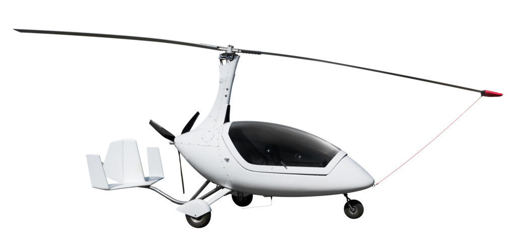
There are occasions where an aerial mapping project is simply too big for a UAV and yet a standard manned aircraft is either too expensive or just plain overkill. That’s where a gyroplane (aka gyrocopter or autogyro) equipped with lidar could be just the ticket. Besides being a low-cost alternative, the gyroplane offers the advantage of less-restrictive pilot licensing.
The FAA has a series of certificates for people who wish to start flying with a minimal amount of red tape. Depending on the gyroplane, it is possible to fly one with a Sport Pilot Certificate in lieu of a full pilot’s license. Gyros are typically very safe as well, thanks to autorotation. In the unlikely event of an engine failure, the pilot can easily glide down and make a gentle landing under full control.
Now to add an aerial lidar solution to the gyroplane. RIEGL’s new VUX-16023 Airborne Laser Scanner seems to be a tailor-made answer. The RIEGL VUX-160²³ allows smooth integration on UAS/UAV/RPAS, as well as on small, crewed aircraft like gyroplanes. It is offered both as stand-alone lidar sensor and in various fully integrated laser scanning system configurations with INS/GNSS system and optional cameras.
The unit offers a 100-degree field of view and a pulse repetition rate of up to 2.4 MHz, making it well-suited for high point density corridor mapping applications. Other missions could include topography in open-cast mining, surveying of urban environments, archeology and cultural heritage documentation, and agriculture and forestry.
Teaming an economical gyroplane with an affordable lidar sensor package could well be a cost-effective solution for in-between aerial surveys.
– Jeff Salmon (jeff.salmon@xyht.com)
Monitoring Biodiversity with UAVs
Purpose-built UAVs can collect eDNA safely and efficiently
The study of Earth’s biodiversity is an important task, however, it is hampered by the challenges associated with collection of environmental DNA (eDNA) and the resultant scarcity of data. For those unfamiliar with the concept of eDNA, USGS explains: “Environmental DNA originates from cellular material shed by organisms (skin, excrement, etc.) into aquatic or terrestrial environments that can be sampled and monitored using new molecular methods. Such methodology is important for the early detection of invasive species as well as the detection of rare and cryptic species.” Add to the list, monitoring biodiversity.
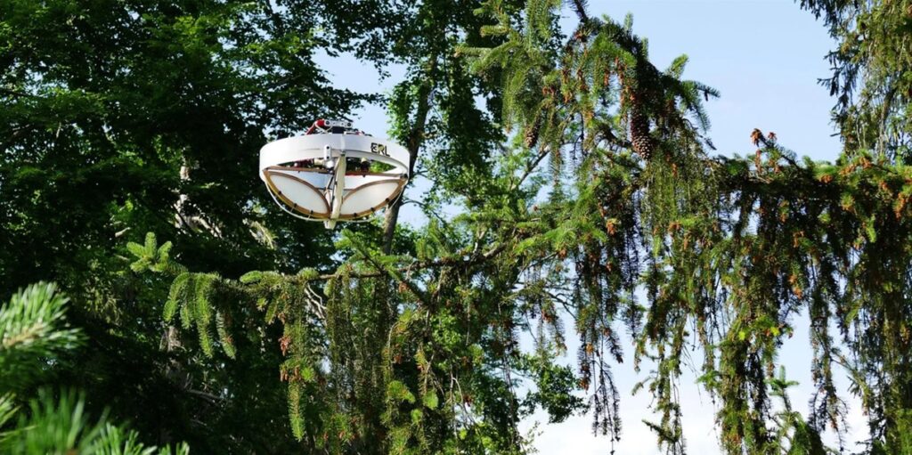
A recent paper in the journal Science, “Drone-Assisted Collection of Environmental DNA from Tree Branches for Biodiversity Monitoring” details a project by the Environmental Robotics Laboratory at the Swiss Federal Institute of Technology (ETH) in Zürich. In the project, a UAV was purpose-built for the task of collecting eDNA from trees. Surface eDNA was collected using an adhesive surface incorporated in the cage of the drone. The project demonstrated that the drone can autonomously land on a variety of branches without prior knowledge of their structural stiffness and strength and successfully collect eDNA.
The drone combined a force-sensing cage with a haptic-based (tactile) control strategy to establish and maintain contact with the upper surface of the branches. Real-world testing demonstrated that the method was successful in detecting animal species, including arthropods and vertebrates.
Combining robotics with eDNA sampling from a variety of unreachable above-ground surfaces can offer a viable solution for broad-scale monitoring of biodiversity.
– Jeff Salmon (jeff.salmon@xyht.com)
To continue reading more from our “From Nadir to Oblique” article in Heights 2023, please click here to be directed to the full digital version.