All posts by Ryan Brazeal
GNSS Next: Do-It-Yourself Internet RTK
Editor’s note: Communications for base-rover RTK corrections can be problematic. The short leash of base-rover radios, not to mention licensing issues, can be a major source of pain for your field operations. The advent of network RTK (RTN) introduced many surveyors to the relative freedom of using cellular, broadband, or other IP- (internet protocol-) enabled...
Software Review: Topcon MAGNET v2.0
Topcon Positioning Group has recently released version 2.0 of its MAGNET system. For those readers who are not yet versed in the field-to-finish approach that is MAGNET, prepare to be excited. If the word “cloud” scares you, don’t worry: there is a vast misconception surrounding what the cloud really is, and I will explain some...
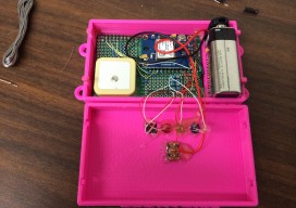
Low-cost DIY GPS Data Logger
It wasn’t that long ago when the ability to create a functioning GPS device was reserved for the big companies, academics, and those with money to burn. Today, thanks to the ever-increasing demand for consumer-grade GPS electronics (such as those in every smart phone), the availability of GPS integrated circuits (chips) has dramatically increased, while...
Future of Determining Elevation
A frank discussion of the different heights used in surveying, what’s inside a geoid model, and how geoid model data is used within GNSS software to produce elevations. Certainly most geospatial professionals who have used Global Navigation Satellite Systems (GNSS) within their surveying workflows have come across the term “geoid model” before. But who actually knows...
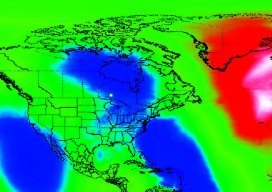
Geoid Model Interpolation Problem
The Canadian federal government recently released the first new vertical datum in 80 years in Canada. The new vertical datum is called the Canadian Geodetic Vertical Datum of 2013 (CGVD2013). The introduction of this new datum not only establishes a more accurate and precise vertical reference system, it also introduces a new methodology for realizing...