Editor’s note: Communications for base-rover RTK corrections can be problematic. The short leash of base-rover radios, not to mention licensing issues, can be a major source of pain for your field operations. The advent of network RTK (RTN) introduced many surveyors to the relative freedom of using cellular, broadband, or other IP- (internet protocol-) enabled mobile communications to transmit and receive RTK corrections. But RTN is not the only way to leverage corrections over IP.
Whether your corrections are for a base you have mounted on a building or at a site or even for a short RTK session, they can be delivered over IP. Of course, this only works in areas where cellular or other wireless internet coverage is available. Some newer GNSS receivers come with IP and NTRIP (read on for details) capabilities as standard features, but with a little ingenuity and some free tools you can IP-enable nearly any RTK receiver to do this. The following article shows you how.
In today’s plugged-in world where it seems that nearly everyone has a personal mobile device that provides 24/7 connectivity to the internet, it is surprising how many surveying companies still primarily use (often illegally unlicensed) UHF radios to transmit differential GNSS corrections. Commercially available 35W positioning UHF radios are most often chosen to transmit corrections because the coverage area they establish can be extensive, they are able to work in most remote and urban environments, and they are fully supported within data collection software. All of these properties are very desirable for single reference station RTK setups and provide an out-of-the-box solution for transmitting corrections.
 There are other radio-based options for transmitting corrections, and each option has certain advantages and disadvantages over UHF radios. Spread spectrum 900MHz radios and long-range Bluetooth or WiFi radios (2.4 GHz or 5GHz) are common options. These radios have the advantages of license-free use and better interference mitigation, but their major disadvantage is that they create a decreased coverage area and are often not a comparable alternative to UHF radios.
The dilemma that radio-based RTK operations face is that the geographic area where RTK corrections from a single reference station can be used to produce survey-grade positions is much larger than the geographic area covered by radios. Hence, a user is not taking full advantage of the potential of the RTK system when using radio-based transmissions for corrections. Using IP-based transmissions for corrections can help users get more functionality from their RTK systems.
A lot of surveying companies do not employ dedicated geomatics–IT personnel and may not know where to start in the process of transmitting their own corrections via the internet. As a result, these companies will often subscribe to fee-based real-time correction services generated from real-time networks (RTN). These subscriptions allow field users to be able to receive corrections via mobile internet connections, which can greatly expand the coverage area for mapping or surveying projects. This may also eliminate the need for each crew to establish its own remote reference station.
These sophisticated RTN often offer many more services than some surveying companies may need (e.g., VRS- or MAC-style corrections). Therefore, a subscription to an RTN could be seen as overkill if a company wants simply to take advantage of the many benefits of internet-based transmission of corrections for the area surrounding their reference station(s). That is not to say that RTN does not have advantages over single reference station RTK systems. RTN provides more consistent correction quality and a means of connecting to a geodetic reference frame over a wide region. But if the range of a single reference station RTK system fits your needs and operations, you can reduce or eliminate radio-based communication legalities and challenges through IP-based communications.
Using free open-source software, any company that operates its own GNSS reference station, has a spare computer with a serial port kicking around, and has an active internet connection can easily transmit their own corrections using NTRIP: Networked Transport of RTCM via Internet Protocol. This article explains how internet-based transmission of differential GNSS corrections works and how to set up such a system within your company.
NTRIP
NTRIP is an open, non-proprietary protocol created by the German Federal Agency for Cartography and Geodesy (BKG). It has been adopted as a disseminating differential correction standard by the RTCM and has been implemented in two versions (NTRIP v1.0 and v2.0). Because NTRIP is a non-proprietary protocol, anybody who is interested in using the protocol can easily acquire the documentation needed to integrate NTRIP into software systems or hardware products. Several industries, including surveying, engineering, and even farming, have fully incorporated NTRIP into products where precise positioning solutions are required.
The NTRIP transmission technique is based on the popular Hypertext Transfer Protocol (HTTP) streaming standard (e.g., internet radio) and uses the client-server principle for transferring data. The server is known as the NTRIP broadcaster (a.k.a. NTRIP caster or simply caster). A caster creates the multiple- and simultaneous-user access to the corrections being transmitted by a single GNSS reference station. It also provides security (via username and password) and management of the connected clients, and it creates mountpoints (i.e., channels a user can connect to) to uniquely identify the different corrections being made available to clients.
Types of clients
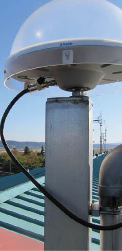
There are two types of clients that connect to a caster. The first is known as an NTRIP server, which is the primary component for sending corrections from a reference station to a caster. This name is often confusing for users new to NTRIP because it often leads field users to think that they need to establish an internet connection to the NTRIP server in order to receive corrections, which is incorrect. An NTRIP server is merely software whose first task is to connect to a GNSS reference station and receive the station’s differential corrections. This connection is commonly via an RS232 serial cable or an inexpensive (~$100) serial-to-IP device server in the case where the computer hosting the NTRIP server is too far away from the reference station.
These device servers work by physically connecting via a serial cable to a reference station receiver and then relaying the correction data over ethernet (either wired or even wirelessly). This allows the reference station receiver and the NTRIP server to be located in different locations, which helps keep the reference station hardware to a minimum. Once the NTRIP server receives the corrections, its next task is to “wrap” the corrections in the NTRIP format before sending them via the internet to a password-protected mountpoint on a caster.
All types of GNSS data can be transmitted using NTRIP, including all types of differential corrections (e.g., CMR+) and even proprietary RAW data messages. Several GNSS receivers on the market today have a built-in NTRIP server. This allows these receivers to be configured to send their corrections directly to an NTRIP caster.
The second type of client is known as, believe it or not, an NTRIP client. This is the system component that people in the field use to receive the corrections from a caster. An NTRIP client is merely software that enables a user to select which caster mountpoint to connect to, provides the caster with username and password information, and most importantly “unwraps” the NTRIP-wrapped corrections to reveal their original format (e.g., RTCM).
Several GNSS manufacturers have native NTRIP clients built into their data collection software or hardware’s firmware. This allows the transition from radio-based transmitted corrections to internet-based transmitted corrections to be very easy because a user does not need to change equipment. Stand-alone third-party NTRIP servers and clients for an array of operating systems are freely available (check out http://igs.bkg.bund.de/ntrip/download for more information).
Advantages
The most significant advantage to using NTRIP for the transmission of corrections is the increased geographic area surrounding a single reference station where DGPS and RTK corrections can be received and applied to yield positions with high precisions. But be aware that IP-based corrections do not increase the practical RTK baseline length. Positional errors continue to increase as the distance between a field user and her selected reference station (i.e., baseline) increases, and these errors need to be closely watched in order to ensure that survey-grade accuracy is maintained.
 Because NTRIP uses the Internet Protocol (remember that is what the ‘IP’ in NTRIP stands for) for transmitting data, all types of mobile internet networks (e.g., GSM, UMTS) can be used to provide system connectivity. As a result, a field user can theoretically receive corrections from a selected reference station from anywhere in the world. This is an obvious advantage for DGPS and RTK systems compared to using UHF radios for the transmission of corrections.
An RTK system using a 35W UHF radio can generally maintain a survey-grade positional solution within 10km (6mi) of a single reference station before the signal strength of the received radio transmission becomes too weak and the corrections become unavailable. An RTK system using mobile internet can generally maintain a survey-grade positional solution within 30km (18mi) or more from a single reference station (though this can vary depending on ionospheric and tropospheric activity) before too much residual error exists within the positioning algorithms and a survey-grade solution will not be possible (even though corrections are still being received). By contrast, RTN can work effectively and consistently with baseline lengths upwards of 60km (37mi), but if you do not need to work past the practical range of your single reference station RTK system, then an internet RTK system can be a great addition to any surveying companies’ GNSS practices.
Setting Up Your Own NTRIP Caster
Lefebure caster
There are several free, open-source NTRIP caster software applications available to the public. One of these is a Microsoft Windows OS-based caster created by Lefebure Design out of Cedar Rapids, Iowa. According to the company, it focuses on “using technology to create smart solutions for the agricultural industry.” The company also describes the intended purpose for their NTRIP caster as: “for use by a single farmer with one base station.” Even though the Lefebure caster was created with precision agriculture applications in mind, it also works very well as a small-scale NTRIP caster for surveying applications.
 The major advantage of the Lefebure caster is realized by companies that have only differential GNSS corrections from a single reference station that they want to make available via the internet. Built into the caster is a single NTRIP server that is designed to read input from an RS232 serial port on the computer hosting the Lefebure caster application. The standard serial port configuration options can be selected to match the serial output from an attached GNSS receiver. This allows for any Windows OS-based personal computer to host the caster application (hence reducing overhead costs). The caster will accept additional GNSS data streams from other external NTRIP servers via TCP/IP connections.
Other advantages of the Lefebure NTRIP caster include the ability to easily create mountpoints and to register users thanks to the simplistic Graphical User Interface (GUI) design of the application. All administrative settings are saved to simple text files in order to preserve the settings between successive starts of the application.
There are a few disadvantages to this caster, including the inability to easily change the TCP port number the caster is listening on for connection requests from other NTRIP servers or NTRIP clients (the TCP port is fixed to port # 5000). The Lefebure caster can theoretically handle an unlimited number of NTRIP server and NTRIP client connections. However, the possibility of having a connection hang idle and timeout increases with more connections made to the caster. Remember, this application was designed for a single farmer and his tractor, not a fleet of RTK rovers!
Lefebure Design has created a simple, lightweight yet very functional NTRIP caster that anyone with basic Microsoft Windows knowledge can easily set up. With a free application like this there is no reason for more surveying companies to not “get with the times” and start taking advantage of all the wonderful aspects that NTRIP and mobile internet access provide for GNSS surveying and mapping projects.
How to Set Up the Lefebure Caster
- Select a computer that has an RS232 serial port and internet access.
- Download the Lefebure NTRIP caster compiled program from http://lefebure.com/software/ntripcaster.
- Configure the computer for public access via the internet and record its public IP (v4) address and port number. This is a common network administrator task, but if you are tackling this task yourself Google “network port forwarding” for help.
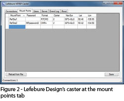
- Start the Lefebure caster application, and on the mountpoints tab create at least one mountpoint for the internal NTRIP server to use. A default password is not required for the internal NTRIP server’s mountpoint, but external NTRIP servers (if any) will need a password for their mountpoints. Be sure to specify the format of the corrections, the number of GNSS carrier signals present in the corrections, the specific navigation system(s) present in the corrections, and the approximate geographic coordinates of the reference station for each mountpoint. Click the save button (see Figure 2).
- On the users tab, add usernames and passwords for all the registered users being allowed access to the caster. Each registered user will have access to all the mountpoints within the caster. Click the save button.
- On the server tab, type the name of the existing mountpoint that the internal NTRIP server is to use. Select the computer serial port along with the baud rate and number of data bits that match those of the outputting serial port on the connected GNSS receiver. Click the connect button to begin streaming the receiver’s corrections to the specified mountpoint on the caster (see Figure 3).
You now are ready to start having users connect to the caster and experience the advantages of internet-based transmission of differential GNSS corrections. In order for an NTRIP client or NTRIP server to connect to the caster, the public IP (v4) address and port number of the host computer needs to be made available to users. For NTRIP clients to connect, a registered username and password must be used. For external NTRIP servers to connect, a new or unused mountpoint must be available and the name of the mountpoint along with its password must be provided to the administrator of the external NTRIP server.
Once NTRIP clients or external NTRIP servers connect to the caster, the connections tab will display the vital information for each connection.
Linux OS-based caster
The most robust option for implementing your own NTRIP caster is a Linux OS-based caster created directly by the inventors of NTRIP, BKG. The advantages of the BKG caster (standard edition) are that it is very stable and reliable and will easily handle most surveying companies’ needs for transmitting differential GNSS corrections from individual reference stations. It easily handles multiple client connections and allows a maximum of 50 NTRIP server connections and 100 NTRIP client connections simultaneously.
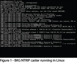
The disadvantages of using this caster include the fact that Linux terminal command line knowledge is required to compile, install, manage, and start the caster (see Figure 1). The BKG caster has no GUI, so all configuration changes are made within text files. Any changes made to the configuration of the caster require it to be restarted, which will kick off all connected clients.
For those who are interested in having corrections only from a single GNSS reference station made available via the internet, the BKG caster does not have a built-in NTRIP server. In order to have corrections sent to the BKG caster, an intermediary NTRIP server would need to be used between the GNSS reference station receiver and the caster. (BKG also offers a professional version NTRIP caster [price 1000€, ~ US$1,350] that adds many additional management and performance improvements over the standard edition caster.)