Category Archives: Spatial IT/GIS
Embrace the Mesh
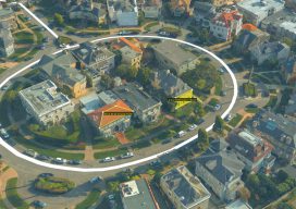
Above: A full 3D textured model of San Francisco produced through Skyline’s PhotoMesh 3D Reconstruction software and streamed for visualization and analytics in Skyline’s TerraExplorer. Surveyors and photogrammetrists capture reality data. But to model, manage, and provide access to massive and complex datasets—to provide your clients with true 3D mesh reality capture—you’re going to need...

In the Blink of an AI
If we were to believe Steven Spielberg’s version of the future, curiously, robots can’t blink. It seems like mechas, as the life-like robots in his movie AI: Artificial Intelligence are called, lack the AI codes to involuntarily close and open their mechanical eyelids. Notice how almost all robots in Hollywood movies follow the same no-blinking pattern. Watch The Terminator movies, if you don’t...

Ocean Business 2019
With preliminary surveys already starting around the coast of the UK for another round of wind farms being built, the offshore industry descended on the National Oceanographic Centre in Southampton, UK for the bi-annual event, Ocean Business, centered around the offshore survey industry. Luckily, my home is a walk away from the event, so I was more than happy...
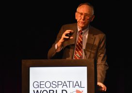
Geospatial World Forum 2019
At the GFW19, the geospatial industry, community, and professions find common ground to promote geo-business, to showcase innovation, and to collaborate to seek solutions for global issues. I’d like to emphasize the word “forum.” The Geospatial World Forum 2019 (GWF2019), held in April in Amsterdam, holds a special distinction and role in the global geospatial...

Be Critical of the Data
Image above: The author’s view of Lake Michigan as he walked toward the lighthouse at Manitowoc. Not long ago, obtaining data for a surveying or GIS-based project was an arduous task. Because great time and effort was involved with either creating your own data or obtaining data that someone else created, you had to think...
Hayden’s Survey in 3D
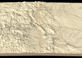
Above image: Hayden’s triangulation survey map is overlaid on a digital elevation model. A GIS project visualizes the fascinating triangulation network created for the historic Hayden survey of Colorado. One of the great surveyors in the American West is undoubtedly Ferdinand Vandeveer Hayden. A physician during the Civil war, he rose to be chief medical...