Precision agriculture consists primarily of using geospatial technologies to map spatial variations in crop and soil conditions and to match inputs—such as water, seed, and fertilizer—to those variations by applying them at variable rates. The link between the spatial variations and the variable rates are zone maps and prescription maps. The former show the difference between healthy and stressed plants by representing the amount of light they’re reflecting in different bands of the electromagnetic spectrum. The latter tell growers how much input to apply to each one of small areas known as management zones.
The data used to create zone maps is collected by sensors on the ground and in the sky. The advent of unmanned aerial systems (UAS) and the sharp increase now taking place in the number of Earth observation satellites are increasing the quantity and quality of these data that are available to growers and agricultural consultants. This bird’s-eye view helps them swiftly detect in-season problems with nutrient deficiencies, pests, or disease, giving them the best opportunity to
correct factors that could limit crop performance and compromise yield potential.
Until recently, the usefulness of satellite remote sensing to growers was limited by long re-visit times, cloud cover, total cost, poor spatial resolution, and insufficient techniques and facilities to process imagery for agricultural applications. Some farm management decisions, such as weed detection and management, require imagery with a spatial resolution in the order of centimeters and, for emergent situations (such as to monitor nutrient stress and disease), a temporal resolution of less than 24 hours.
These requirements are well beyond the spatial abilities of medium-resolution satellites—such as Landsat 8 and Terra—and are at the limit of the re-visit times of higher-resolution satellites—such as WorldView-2 and GeoEye-1. However, with the growing number of satellites and the increase in the resolution of their imagery, both revisit times and ground sample distance are now sufficient for most precision agriculture applications.
Multi-spectral remote sensing from satellites is linked to crop growth and condition through such canopy parameters as the leaf area index (LAI), which measures two basic physiological processes, photosynthesis and evapotranspiration, most dependent on solar radiation. Other estimated measurements using remote sensing data include surface soil properties, nitrogen content, water stress, vegetation cover, above ground biomass, crop species, crop height, crop yield, and weed extent. Many of these parameters are determined using vegetation indices, such as the Normalized Difference Vegetation Index (NDVI).
Recent Developments
Several recent developments with Earth observation satellites have sharply increased their usefulness for precision agriculture.
- In February 2013, NASA launched Landsat-8, the eighth satellite in its Landsat Data Continuity Mission (LDCM), a joint mission with the U.S. Geological Survey that began in 1972. It brought two sensors—the Operational Land Imager (OLI) and the Thermal Infrared Sensor (TIRS)—into low orbit to image Earth’s land surface. Growers can use free Landsat data to map their fields.
- In November 2013, Skybox Imaging launched SkySat-1, the first commercial Earth observation microsatellite. The company is producing and launching a series of 24 microsatellites that deliver sub-meter imagery and video optimized for ongoing change detection.
- In December 2013, Land O’Lakes Inc. acquired Geosys, a firm that provides satellite imaging to agribusinesses. Land O’Lakes’ WinField division has used Geosys technologies for the past several years. In April, WinField launched a version of its R7 Tool, powered by Geosys technology, with imagery from three times the number of satellite imagery providers it had in 2013. Cloud-free maps are targeted to be delivered through the R7 Tool within 72 hours of satellite acquisition. The tool is an interactive, Web-based platform that performs detailed field-by-field analysis and provides on-demand, in-season satellite imagery.
- On January 9, 2014, Planet Labs—which designs, builds, and operates a network of satellites it calls “doves”—delivered Flock 1, the world’s largest constellation of Earth-imaging satellites, made up of 28 doves. On March 17, the company announced that it has confirmed launches for more than 100 satellites over the next 12 months, allowing it to image the whole Earth every 24 hours.
- At the end of February, Blackbridge launched a new service that uses imagery collected by its RapidEye constellation to provide access to a pool of multi-temporal, orthorectified imagery collected throughout the season at 5-meter resolution. Subscribers can access the imagery through cloud-based technology every day shortly after acquisition as well as archived imagery from past seasons.
- In May, Dauria Aerospace, a multinational aerospace company, and Elecnor Deimos, a subsidiary of Elecnor, announced a joint partnership to develop Deimos Perseus, a new constellation of small satellites that will provide frequent imaging of the entire Earth using multispectral sensors that provide for automated identification of ground features such as crop types, their vigor, and their stage in the growing cycle. According to the companies, by 2016, Deimos Perseus will be able to image the entire Earth on a daily basis. The first four Perseus-O satellites are scheduled for deployment in early 2015, with the remaining four planned for the third quarter of that year.
- On June 5, Hexagon Geospatial announced that it had partnered with Skybox Imaging to provide satellite imagery and data processing through ERDAS IMAGINE 2014.
- On June 11, DigitalGlobe announced that the U.S. Department of Commerce had approved its longstanding request to sell images with a resolution of 40 cm, up from 50 cm, effective immediately. The company will also be able to sell images with a resolution of 25 cm six months after it launches its WorldView-3 satellite in mid-August. Using better electro-optical sensors on the new satellite and short-wave infrared equipment, the company will be able to identify individual trees and plants and even the moisture content of soil.
When and where persistent cloud cover, especially during the growing season, defeats this panoply of satellite imaging systems, the solution may be cheap and user-friendly UAS.
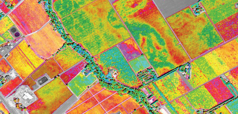
In the above satellite image from DigitalGlobe, green shows healthy crops and red shows unhealthy crops. Courtsey of DigitalGlobe.