Marine scientists bring multiple technologies together to locate reef fish aggregations, working towards healthy reefs and island economies.
The livelihoods of tropical island communities depend on the vitality of reef fishes, either directly through recreational and commercial fishing or indirectly through healthy coral reef ecosystems that support eco-tourism. Yet, over the last several decades, the Caribbean region of the western North Atlantic has experienced a decline in fish abundance and body size compounded by a loss of coral reef habitat and live coral cover.
As part of their reproductive strategy, many economically important Caribbean reef fishes, such as snapper and grouper, aggregate at specific times and locations to spawn. These events, in which dozens to thousands of fish congregate in courtship rituals, are typically timed with the lunar cycle. Individuals of a species may travel a short distance within their home range or may travel hundreds of kilometers to reach the spawning location.
Unfortunately, the predictability of these fish spawning aggregations (FSAs) also makes them particularly vulnerable to overfishing. According to the Gulf and Caribbean Fisheries Institute, a third of the spawning aggregations for Nassau grouper have been extirpated, and likely many more aggregations of other species have also disappeared or their numbers are severely depressed.
While fishing communities in the Caribbean have a working knowledge of FSAs locations, our scientific understanding of the ecological and oceanographic factors that determine the location and timing of FSAs is still incomplete. Is it the horizontal and vertical geometry of the seafloor, oceanographic currents tied to lunar tides, or other factors that influence the location? Why is it that many aggregations are located along shelf-edge/reef promontories?
These knowledge gaps are also further complicated by uncertainty of which FSA sites are currently active and where they may have existed prior to overfishing. Several advanced technologies are helping scientific investigators more effectively detect and document active FSAs and investigate conditions that may explain their preferential locations.
Multi-Scale Approach to Location
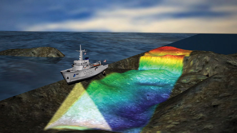
NOAA hydrographic survey ships map the seafloor to support safe navigation and better understanding of the seafloor habitats.
During courtship behavior, several species of grouper make sounds that are recognizable and characteristic of the species. Scientists can use hydrophones to listen for and record these sounds to detect and locate aggregations of fish, but the key is being in the right place at the right time. However, being at the right location can be challenging given that multiple aggregations may occur at the same time but at distant locations.
Scientists from NOAA’s (National Oceanic and Atmospheric Administration) NOS (National Ocean Service) have been teaming with academic partners to map, characterize, and better understand the distribution and health of reef fish communities and habitats, particularly focusing on FSAs. To meet this need, NOAA has had to implement technological solutions to collect data and provide products at multiple spatial scales.

Co-author Taylor attaches the passive acoustic recorder on the Slocum ocean glider.
For instance, assessments of coral reef ecosystems are most informative to resource managers when they depict the distribution of resources at larger spatial scales. While methods are available to map surficial geology, geomorphology, and benthic habitat type, the distribution of fishes and other living marine resources typically needs to be conducted at finer spatial resolutions. However, covering large areas in high detail requires time and resources necessitating a compromise between the extent of coverage and the level of details that can be attained.
A scalable approach is being implemented in the Caribbean to provide the framework for coral reef ecosystem assessments. To address this, NOAA has implemented the use of three technological tiers to span the range of spatial extent, level of detail, and commensurate cost associated with the science activities.
Multibeam and Sonar on a Ship
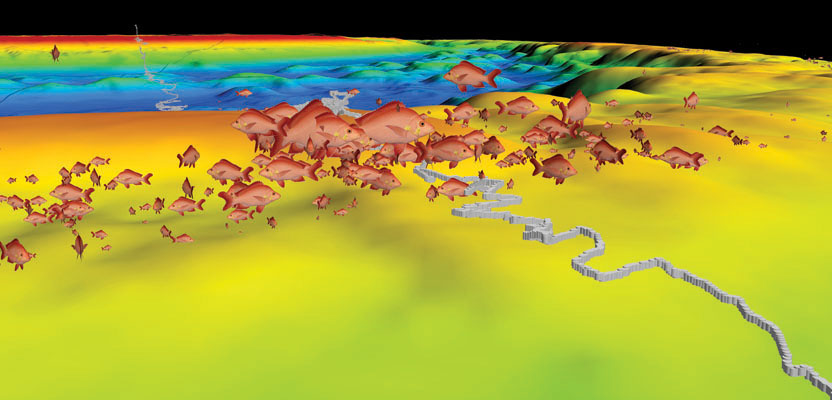
The first tier involves high-resolution, ship-based hydrographic multibeam and fishery sonar surveys to synoptically characterize seafloor topography and habitat type coincident with fish abundance. Tropical reef distribution is highly correlated with seafloor topography and habitat type. The detailed mapping of the seascape is the fundamental baselayer to discern these patterns and associations.
Lang Bank, St Croix USVI is an exceptional example of the important linkages between seafloor topography and fish abundance. This promontory extends approximately 15 km east of St Croix and is comprised of a rich combination of deep narrow terraces, steep outer shelf edge, shelf break, a surrounding concave ridge, an inner deep basin, and an interior platform. Depths of this promontory range from 10 m to greater than 1000 m, and the acoustic technologies onboard the NOAA ship Nancy Foster (hydrographic multibeam – 95 kHz and 400 kHz; fishery sonar – 38, 120 and 200 kHz) allowed for seamless mapping through the entire depth range of Lang Bank.
Acoustic Record on a Glider
Through a partnership with the Naval Oceanographic Office in Stennis, Mississippi, the NOAA research team was able to bring along a Slocum electric glider for the 2014 mission to St. Croix and Lang Bank. The ocean glider uses pumps and internal weights to change buoyancy and attitude, and a pair of wings glide and undulate the vehicle through the water column. Sensors on the glider record depth, temperature, salinity, dissolved oxygen, and ambient light.
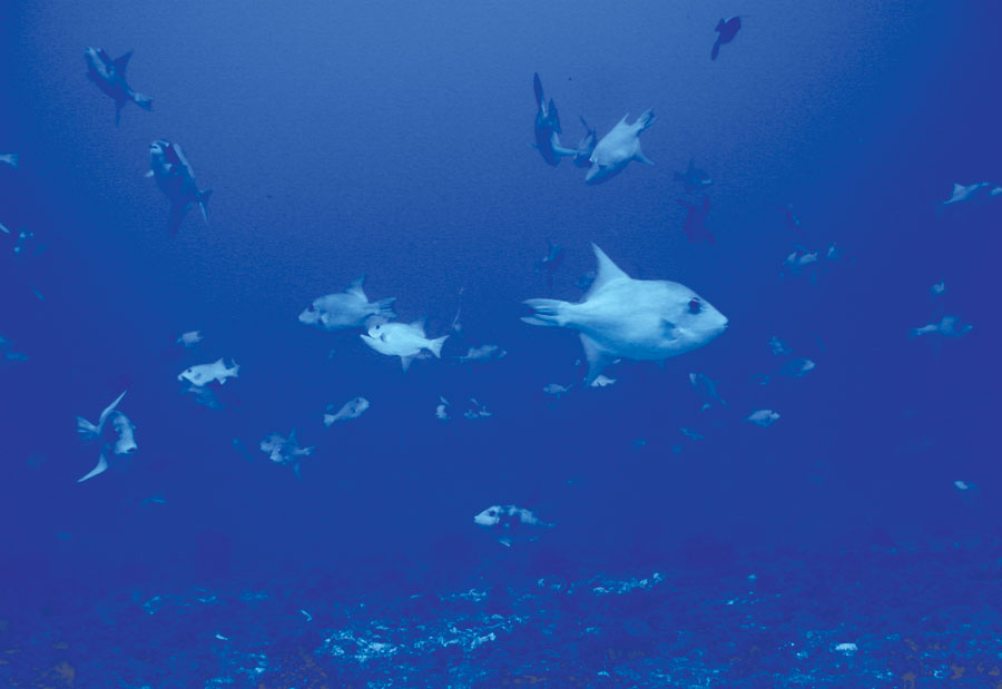
Queen triggerfish don’t aggregate per se; they congregate to form nests that they then guard. This group was located via sonar outside the area they’d been expected to be.
Gliders are used worldwide to measure properties of the ocean to better understand ocean currents, ocean productivity, and climate change. Attached to this glider was an underwater recorder that records sounds made by fish, marine mammals, and man (such as fishing boats and ships).
The Remora-ST, a passive acoustic recorder manufactured by Loggerhead Instruments, is a small, low-power autonomous recorder that is easily attached to the outside housing of a Slocum electric glider. The Remora-ST is programmed to record one minute of sound every seven minutes, with enough memory and battery power to last approximately 30 days at sea.
The glider was programmed with a series of waypoints that it follows when it surfaces, using the position it receives from GPS satellites and piloted by a glider operator at the Naval Oceanographic Office. The path would take the glider over reported spawning aggregation sites in and around the Red Hind Marine Conservation District (MCD) on the east end of Lang Bank, St. Croix, when it then traversed along the southern insular shelf of St. Croix during a two- to three- week mission.
Video on an ROV
Finally, remotely operated vehicles are deployed at fish aggregation hotspots detected during fish acoustic surveys to provide high-resolution visual documentation at discrete sites. The SubAtlantic Mohawk 18 ROV, operated by University of North Carolina at Wilmington’s undersea vehicle program, provides real-time observations with high-definition video, digital still cameras, dual-green scaling lasers, LED lights, and high-accuracy navigation and vehicle tracking.
The ROV can be deployed to depths as great as 300m and can provide the most detailed information on the health, diversity, and abundance of corals, benthic biologic organisms, and coral reef fishes. The vehicle is guided along a
prescribed path, with the location superimposed over a bathymetry or habitat map layer that was derived from the multibeam or fishery sonar. At a nominal speed of 1 kt or less and limited by light levels, survey coverage by the ROV can be limiting.
The entire bank was surveyed by NOAA ship Nancy Foster in 2014. Mapping activities were able to document a diverse assortment of soft and hard corals, sponges, other marine invertebrates, relic reef, sand, pavement, reef rubble, and a rich assembly of reef fish and aggregations. Not surprisingly, commercial trap fishing was also very active along the bank (with the exception of the Red Hind Spawning Aggregation Area, which is seasonally closed to fishing).
Lang Bank: A Hotspot for Fish Activity
Acquiring fishery sonar data simultaneously with the multibeam sonar mapping allowed the research team to cover a very large area over Lang Bank and map the distribution of several fish aggregations. After completing the mapping component, the ship returned to some of the aggregations for further study. The ship traversed shorter transects over smaller areas to provide higher-resolution maps of the fish densities and shapes of the aggregations. Many of the aggregations were located near the outer reef ridge.
Interestingly, many of the aggregations were detected outside the Red Hind MCD on Lang Bank. There was also an interesting fish distribution pattern that was found on the middle and upper terrace of Lang Bank. Dr. Richard Nemeth, professor of marine biology at the University of Virgin Islands, provided coordinates for a region where queen triggerfish had been observed exhibiting spawning behavior and maintaining nests. The species does not aggregate per se; rather they congregate in an area and form nests that are guarded for some time. The fishery sonar detected many fish over a relatively low-relief habitat that was adjacent to high-relief reef.
Not every aggregation of fish is necessarily a spawning aggregation. Some species of reef fish form large schools throughout the year as a mechanism to aid in feeding or to avoid predation. The fishery sonar can elucidate the shape, size, and density of the fish aggregations as well as provide an indication of the size of fish.
Unfortunately, it is not yet possible (with current technology) to identify the species with acoustics alone. The research team relies on the ROV to identify the species and make observations on the behavior and coloration that may indicate courtship, spawning, or other behaviors. The fishery sonar observations provide an informed starting point for ROV observations, resulting in a cost-efficient method to conduct surveys on coral reefs.
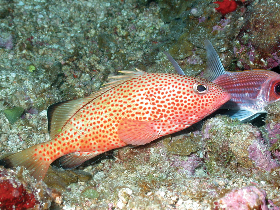
A red hind grouper on coral reef habitat.
In many cases, the aggregations were a mix of species. Observations throughout the Caribbean show that some FSA sites may act as multi-species aggregation sites. Species of jacks and ocean triggerfish were observed in the water column in several areas on the outer reef ridge. As the fishery sonar and ROV surveys moved deeper, the species changed.
To the team’s surprise, a large group of deep-water snapper, including blackfin and silk snapper, were aggregated in 200 to 300m on the steep slope, outside the existing Red Hind management zone. According to the scientific literature, it is common to see snapper form groups not necessarily related to spawning, but the distribution and habitat use by the species is not well understood. According to researchers in the Caribbean Fishery Management Council, the deep-water snapper are an emerging fishery sought by commercial and recreational fishermen. The depths occupied by the snappers make it challenging to study with any tool but an ROV, but the costs to conduct a survey of all regions 200 to 300m deep along the outer ridge would be prohibitive.
The combination of fishery sonar to detect fishes and rapid deployment of an ROV to study the species and behavior, and possibly to observe spawning activity, is one of the greatest advantages of the coordinated technology framework described here.
Advanced Technology: Not without Risk
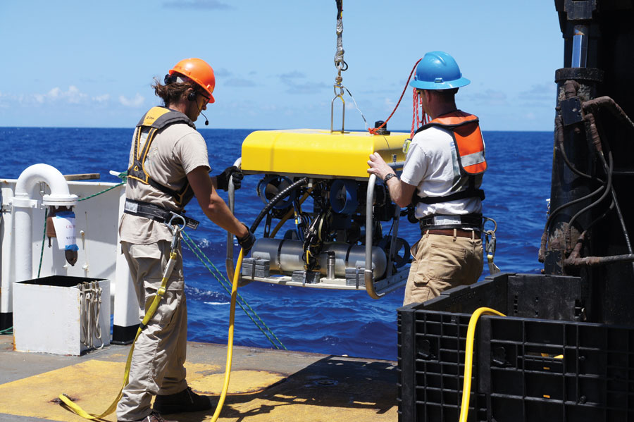
NOAA and UNCW scientists deploy SubAtlantic Mohawk
18 ROV from the NOAA ship Nancy Foster.
The Slocum ocean glider was intended to serve as a reconnaissance tool, exploring more area than the ship could accomplish alone. The research team was able to track the glider remotely from the NOAA ship Nancy Foster as the glider broadcasted its position at every surfacing via satellite communication back to the Naval Glider Operations Center.
Then an ominous email subject was received early on the second morning of the mission: “Glider ng001: Glider ABORT.” Diagnostics received by satellites and analyzed by the Navy suggested a failure in one of the buoyancy pumps. The glider ejected one of its weights and was adrift at the surface. The communications systems were still sending coordinates as it drifted over Lang Bank, and the ship’s crew made plans to retrieve it using one of the small boats on the Nancy Foster. A small fishing boat was also working in the area and noticed the yellow torpedo floating adrift.
Thankful to the fishers, the glider was delivered to the ship undamaged. Unfortunately, it was not possible to repair and redeploy the glider on the ship, marking the end of this very short scientific journey. During the 18-hour mission, the glider did not record any sounds made by fish but did record several vocalizations from humpback whales.
Lessons and the Future
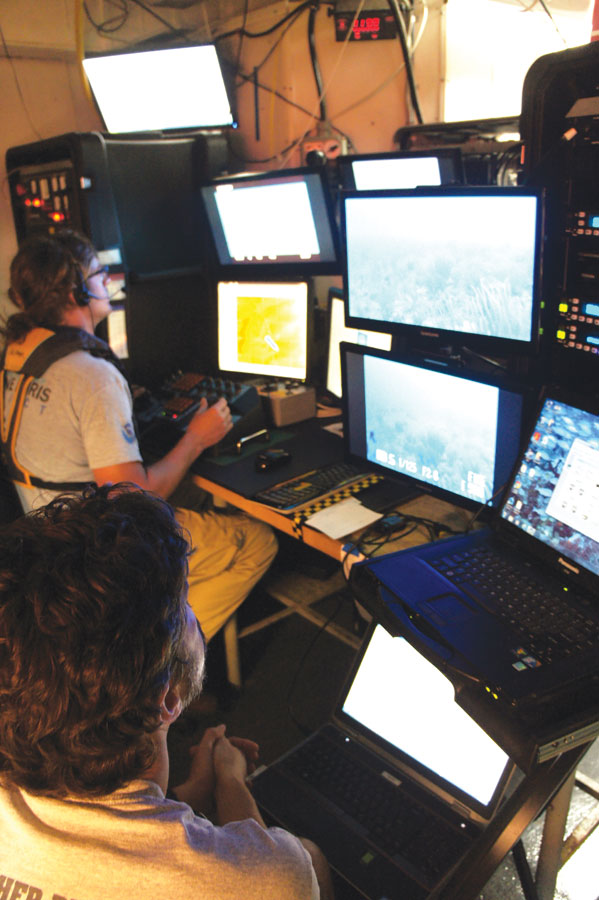
A NOAA scientist and an UNCW ROV operator man the topside vehicle control station during an underwater dive to detect and observe fish aggregations.
The advanced technology framework used by NOAA employs a suite of technologies to provide broad mapping coverage at high spatial resolution. The approach takes advantage of several acoustic technologies to describe the topography of the seafloor and the fishes that reside in the coral reef habitats. At the core of the approach is recognition of the cost and manpower required to conduct observations that provide the required resolution and level of detail. The key is to provide the highest level of detail where it is needed most: in the case of addressing coral reef conservation and management needs, the needs are to better understand what drives hot spots for fish biomass, fish spawning aggregation, and healthy coral reef habitats.
Despite the challenges experienced by the team during the glider mission, they are confident that this tool will become an integral component of future coral reef ecosystem assessments. Indeed, the team is already planning their mission to be conducted in spring 2015. From the results in 2014, the team will focus their attention on the deep habitats used by the snappers near Lang Bank and potentially similar habitats in other regions of the U.S. Virgin Islands.
The NOAA team is honored to work with academic and management partners to conduct research and ecosystem assessments that are of greatest need to ensure the sustainability and conservation of fragile coral reef ecosystems that support the ecology and economies of the U.S. Caribbean and other island nations in the Caribbean. This work was supported by NOAA’s Coral Reef Conservation Program.