 Ever since I first started working with GIS, a lot of the most valuable data came from CAD users. At first there was a chasm between the CAD and GIS worlds—different approaches, different tools, different ways of representing things in the real world, different ideas about accuracy. Gradually users on both sides started reaching out.
Today, the majority of CAD users still use AutoCAD and the majority of GIS users still have trouble incorporating data into GIS. Synergy does happen, but there are still hoops to jump through.
Esri has long been seen by many as a gatekeeper of geographic information. With their own formats and tools, they have steadily taken over the GIS world. They have tried many different ways to make things easier for both worlds to work together—using CAD files directly, putting GIS tools inside AutoCAD (ArcCAD over 10 years ago), translating CAD data, putting CAD tools inside ArcGIS (or so they say!), storing measurements and adjusting them with LSA— and with each attempt the marketing message rang loud: “CAD and GIS users can now work together!”
Recently, the marketing message included the phrase “exponential leap.” I wonder. In all my travels I’ve never met many surveyors and GIS analysts who truly worked together as well as they could. Their own worlds need them too much.
What’s New This Time?
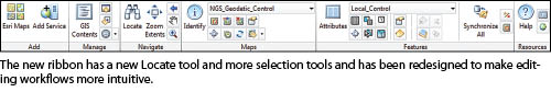
 ArcGIS for AutoCAD is Esri’s no-cost plug-in and has iterated through several releases during the past five years. Back in July 2011, I wrote about this plug-in, and a year later there is a new release, build 300. Since that release, Esri has updated the ribbon with some new tools and added a new table of contents area for the GIS layers in the drawing.
According to Esri, this release also delivers a long-requested enhancement that users have asked for: the ability to edit and extract geodatabase features from within AutoCAD. Finally, AutoCAD users will be able to “plug in” with read/write access to GIS databases.
That is a pretty powerful function; no longer are Esri tools the only technology that can edit the GIS databases that are being used even more for significant decision making. From within AutoCAD, you can create drawing layers on the fly, track changes, and then send back CAD entities that are converted into GIS features. Sounds magical! Remember, this is happening without conversion; it uses GIS web services to share the geometry common between GIS features and CAD entities. The only catch is the GIS database has to be “served” via ArcGIS for Server, which is easy enough for the GIS folks to do with the right Esri software (although there is still easier exchange of DWG data, as I found out).
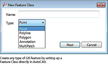
Create GIS-Ready AutoCAD Drawings
GIS people usually have a hard time making sense of CAD files. They are used to a different data model, and trying to work out which layers, levels, and entities represent GIS features is always challenging.
Even without the magical direct access to GIS, if the database is hosted within ArcGIS for Server, you can still share data much more easily with GIS users than before. With ArcGIS for AutoCAD, you can easily set up and edit GIS feature classes within your drawing.
When the DWG is opened in ArcGIS for Desktop, the GIS user doesn’t see the layers, levels, and entities (although they are all still there); he or she sees GIS points, lines, and polygons. This is powerful and prevents any misinterpretation on the part of the GIS user as to what in the drawing is the relevant data being shared.
New Map Layers
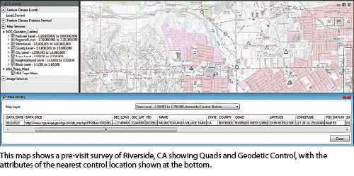
Esri maintains a gigantic GIS database online, and it includes a lot of map layers that are interesting for surveyors. The datasheet layer of control points is still there, but a new map of Geodetic Control includes many more reference stations and includes the CORS network. With a few clicks, you can see where the nearest stations are to the area around your drawing without leaving AutoCAD! Combine that with Imagery and Quads, and you can get a great pre-visit survey done.
Location Services
My final favorite feature also provides a lot of value: You can add points where there is a match from an online database of place names, coordinates, and addresses. Click Locate, and the value you are searching for adds a point entity to the drawing at its known coordinate location. The point features are created as members of a special feature class called ESRI_Locations, which makes zooming to them a simple matter of opening the attribute table viewer and using the Zoom to Selected Features tool. This alone might be reason enough to grab the plug-in.
As much as Esri would like to think of this as an “exponential leap,” I prefer to think of it as a great evolution of tools that have been available for a while. This version definitely makes it easier for CAD users to plug in to the GIS database and for them to more seamlessly exchange data, but in my experience, the reason CAD and GIS users don’t sit side by side working together isn’t really about the technology, is it? It’s about culture, organizational barriers, and awareness of what is possible.
More Information
For more on the technical details and usages of the plugin, you can review last year’s article. If you like what you read, visit esri.com/autocadapp to get an overview of the key features, answers to frequently asked questions, and a download link. Remember, if you have anything you’d like to ask me about this article or anything else related to GIS technology for CAD users, I can be reached at ray@profsurv.com.