Once again I traveled to that desert paradise we call Las Vegas to attend the Commercial UAV Expo. And once again I was invited to participate in the “Pitch the Press” event. A panel of five “high profile press representatives,” including me, listened to pitches from 15 innovative UAS firms touting the newest offerings. So let’s get started with the winners and then take a peek at what the other finalists had to offer.
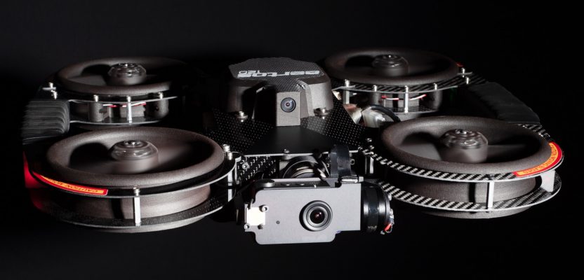
(Above is the Aertos 120.)
Agrowing Ltd.’s New Multispectral Sensor
Those in the precision ag space will want to take note of Agrowing’s Al-enabled 12 narrow band multispectral sensor with 12MP per band. As of now, Agrowing takes the lead in terms of number of sensors and accuracy.
The sensor enables the acquisition of multispectral imagery from as close as 3m (sub 0.4mm per pixel) and at sub 1.5cm per pixel from 100m altitude.
A2Z’s Free-fall Drone Delivery Mechanism
Although this was a winner in the event, the technology doesn’t really align with the geospatial sector. Suffice it to say it is a unique method to making drone deliveries. If you’re interested, you can find out more on the firm’s website.
SolSpec UAS Analytics
SolSpec is a new drone analytics software platform designed to turn data in actionable information. It is designed to simplify the way aerial data is collected, processed, viewed, and shared to enable asset managers and UAS operators a way to maximize the value of collected aerial data. Find out more on the company’s website.
Runners Up
As you can tell from the above, the Commercial UAV Expo is widely focused on all UAS applications. As your Pangaea editor, I’m focused on the geospatial angle, so here are a couple of additional items for your consideration.

Aertos120
Digital Aerolus’ Aertos UAS for Confined Space Inspections
Inspection is a growing UAS application, and a challenging one at that. Kansas City, Missouri-based Digital Aerolus introduced its new Aertos 120 designed specifically for confined space, GPS-denied environments. Typical applications include inspection missions of grain elevators, under/inside bridge framework, power plants, steel or concrete culverts, mines, storage tanks, and other challenging areas. Learn more on the company’s website.
AeroVironment’s Quantix UAS
Back at the precision ag sector I found the Quantix, a tail-sitter fixed-wing VTOL UAS. The unit can survey up to 400 acres in just 45 minutes, while integrated sensors capture high-resolution color and multispectral imagery with dual 18MP cameras. A new trend, on-board processing, delivers true color and NDVI imagery available as soon as the drone lands. Pricing starts at under $6K. Get the details on the website.
But wait, there’s more. Stay tuned for the December issue of xyHt where more coverage is in the Located section.

This article appeared in xyHt‘s e-newsletter, Pangaea. We email it once a month, and it covers a variety of unusual geospatial topics in a conversational tone. You’re welcome to subscribe to the e-newsletter here. (You’ll also receive the once-monthly Field Notes newsletter with your subscription.)