All posts by Jeff Thoreson

Doers: Matt LaLuzerne
LaLuzerne is Strategic Growth Director, GPI Geospatial and incoming president of the Florida Region of ASPRS xyHt: How did you get started in the geospatial industry? LaLuzerne: During my undergraduate studies at the University of Florida, I focused heavily on pre-engineering courses to prepare myself for civil engineering. I would always see a small advertisement in the...

Dis-Located: America’s Two Feet
Buried in the October 5 edition of the Federal Register — the daily publication that meticulously and officially records the minutiae of the federal government — was the notice “Depreciation of the United States Survey Foot.” Since 1893 the U.S Survey Foot has been one of the standards by which surveyors plot the country. But we’ve...

Survey Says: Height of Mount Everest is Two Feet More
Since 1856 China and Nepal have argued over the actual height of Mount Everest, the world’s tallest mountain that sits on the border between the two countries in the Himalaya Mountains. Until today (December 8, 2020), Nepal has measured Everest at 29,029 feet. That counts the ice cap on top of the actual height of...

Digital Coast Act Becomes Law This Week
The Digital Coast Act, now approved by both chambers of Congress, will become law this week, and that is a significant step toward expanding and making accessible geospatial data to support environmental and economic development activities in the coastal regions of the United States. The bill creates a program within the National Oceanic and Atmospheric...
George Washington, Surveyor
If what you know about George Washington comes from your primary and secondary education— —Then John Berlau’s new book George Washington, Entrepreneur (St. Martin’s Publishing Group, $28.99) holds a treasure trove of information for you—especially for surveyors. Our US education tells us Washington was a great military leader, a diplomatic statesman, and a political pragmatist,...
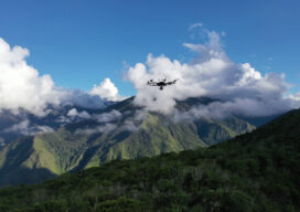
Geospatial Adventure: Mapping Ruins from Above in Peru
It wasn’t quite an Indiana Jones adventure, but Alabama-based lidar consultant Robert Graham says it’s as close as he’ll ever come to the hair-raising exploits of an audacious archaeology professor. Graham’s adventure last April did not revolve around an ark, though it did include ancient ruins, small planes landing in grass fields, machetes hacking through...