All posts by Matteo Luccio
From Shore to Floor
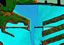
Today’s technology records depth from land to deep waters accurately and efficiently. More than 90% of the world’s trade is carried by sea, according to the International Maritime Organization. Therefore, accurate and up-to-date charts of coastal waters for ship navigation are vital for world commerce. The current expansion of the Panama Canal, which will double...
Mobile System Alerts Dubai Drivers of Approaching Sandstorms
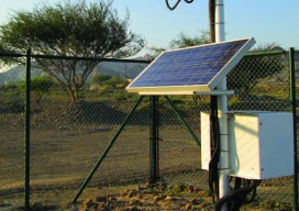
Periodically, large sandstorms and low-visibility conditions wreak havoc in the Middle East, with potentially deadly consequences for drivers. In 2007, a sandstorm in Saudi Arabia caused a pileup involving about 80 cars. In 2008, low-visibility conditions caused a 200-car pileup on the border between Dubai and Abu Dhabi, killing about 25 people. In April 2012, a...
New Markets for Satellite Imagery
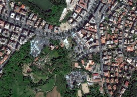
In June, the U.S. Department of Commerce, granting a request by DigitalGlobe, gave the company permission to sell its imagery at the best resolutions available from its current constellation. Additionally, six months after its new WorldView-3 satellite is operational, DigitalGlobe will be permitted to sell imagery at a resolution of up to 0.25 meters panchromatic and...
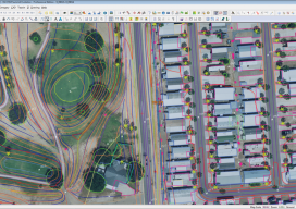
From Traditional Photogrammetry to UAS
Photogrammetry has changed substantially in the past three decades. When Jeff Yates began in the business 32 years ago, he used a projection system known as a Kelsh two-bucket plotter. “That was four generations ago of photogrammetric systems hardware,” he recalls. “From there, we went to the analog stereo plotter. That was the second big...
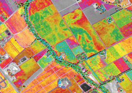
Satellite Imagery for Precision Agriculture
Precision agriculture consists primarily of using geospatial technologies to map spatial variations in crop and soil conditions and to match inputs—such as water, seed, and fertilizer—to those variations by applying them at variable rates. The link between the spatial variations and the variable rates are zone maps and prescription maps. The former show the difference...
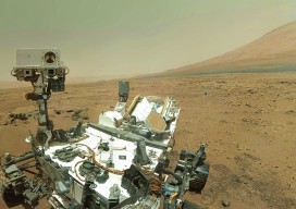
Cardinal Systems’ Extraterrestrial Photogrammetry
On Earth, photogrammetrists can normally use man-made objects in their frame—such as a road of known width or a curb of known height—as scales. When none is present, they can insert such “ground truth” as needed—for example, by placing onto surveyed locations targets that will be visible in their images. On other planets in our...