All posts by Matteo Luccio
Feature: Surveying Cultural Heritage
To help preserve and manage cultural heritage sites, an interdisciplinary team is using 3D laser scanning and photogrammetry to model the sites at high resolution—meeting unique challenges with innovative techniques and creating novel opportunities for surveyors. CyArk, a nonprofit organization dedicated to digitally preserving and sharing the world’s cultural heritage, uses laser scanners to generate...
Feature: Hydrography by Remote
Surveyors in parched California measure sedimentation levels in a reservoir using a small, remote-controlled boat integrated with a survey-grade RTK. Before they even start taking measurements, surveyors often have to deal with such practical challenges as how to access and move around in their survey area—which may be rocky, filled with dense vegetation, or obstructed...
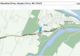
Navigating Without Addresses
New codes aim to bring billions of people into the geospatial market. When we mail a letter to an address in an industrialized country or navigate to that location, we rely, without giving it much thought, on a centuries-old system of street names and numbers, augmented in the case of mail by the later invention...
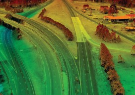
Satellite Imagery’s Impact
Above: The highest resolution of commercial satellite imagery is still more than an order of magnitude lower than the highest resolution attainable from aerial platforms. Keystone Aerial Surveys, Inc. developed this digital surface model from 1.75 cm digital imagery taken with a low-altitude flight. The resolution is sufficiently high to enable its use for mapping...
Feature: Under Thin Ice
An exceptional set of explorers surveys the caves inside a dying glacier on the side of Mt. Hood in Oregon. All photos courtesy of Brent McGregor, except where noted. Editor’s Note: High-profile scientific questions permeate the public consciousness, and surveying, mapping, and field data collection are the “ground truth” element of geophysical scientific research. This...
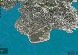
CLIVE: Communicating Risk in 3D
Above: The current sea level and coastline of the city of Charlottetown on Prince Edward Island, Canada. Static 3D models of topography and buildings are commonplace in both technical and popular geospatial software. There are still very few 3D tools, however, that enable users to geo-visualize dynamic phenomena, such as the effects of climate...