All posts by Matteo Luccio
NavCom GNSS: Moving Dirt Just Right
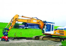
GNSS receivers help steer earth movers, providing users with accurate positions and no complexities. NavCom–a wholly owned subsidiary of John Deere–manufactures GNSS (global navigation satellite system) receivers for land survey, machine control, offshore, and military and government applications. One of its OEM partners is MOBA Mobile Automation AG, a German company specializing in measurement and...

Space Engineering in Training
Above: Morgan Ré aided engineers at NASA’s Langley Research Center as they prepared for a series of nine drop tests of an Orion crew capsule model. Credit: NASA Think young people aren’t getting enough hands-on experience with geospatial looks and skills? Check out this high-schooler. Last summer, NASA dropped three small airplanes from 100 feet in...
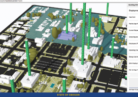
A State Gets Smart: SmarterBetterCities
To create and share interactive 3D building models, Oregon adopts SmarterBetterCities. To help formulate a 10-year strategic capital investment plan for the State of Oregon, the state’s Chief Financial Office (CFO) wanted to develop a dynamic, immersive, and collaborative visual platform that would illuminate key issues often lost in a tabular summary. Its audience was...

Using CartoDB
Above: This choropleth map of the distribution of street trees by neighborhood in Porland, Oregon, was created in CartoDB in eight minutes, using public data. From creating a map in eight minutes to creating market predictions based on streamlined analysis. Among the many mapping programs available, CartoDB stands out for its ease of use and sophistication....

The Process of BIM
Above: An InfraWorks 360 model of downtown San Francisco. Image courtesy of Autodesk. An analysis of Autodesk’s software suite, BIM 360, reveals how BIM< can give project stakeholders unique access and insight across all phases of the AEC design process. Large modern buildings are permeated with sensors and systems—plumbing, electrical, heating, cooling, ventilation, security, elevators,...
Advancing GNSS: Full Interview with Jan Van Hees & Bruno Bougard
Jan Van Hees, Septentrio’s Business Development Manager, and R&D Director Bruno Bougard Click here for the truncated version of this interview that appeared in the February 2016 print issue of xyHt. Septentrio was started as a spin-off of IMEC and attracts talent from KULeuven University as well as from around the world. What is the current...