All posts by Scott Martin
Shake, Rattle & Roll: Disruptions to the Geodetic Fabric
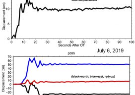
On July 4, 2019 the desert region near Ridegcrest, California was hit with a magnitude 6.4 earthquake, resulting in minor damage in the area, most significantly to the infrastructure at the Naval Air Weapons Station at China Lake. Approximately 44 hours later on July 6th, a larger earthquake of magnitude 7.1 struck the region, causing...
The “Ah Ha” Moments, Part 2
Last month I wrote of two “Ah Ha” moments early in my career: situations where the “light came on” from a surveying experience, even if the value of the moment wasn’t fully understood at the time. In this issue, I share a couple more: where a practical application cemented abstract concepts and where a lack...

The “Ah Ha” Moments
I can’t speak about other professional career paths, but I can certainly attest to land surveying after more than 40 years of “practicing” the art and science. There truly has been an opportunity to learn something new almost every day of those 40-plus years (unless I interfered). From the fundamental basics like stocking the survey...
2019 Geospatial Summit
You Can’t Beat the Price of Admission As the march towards the new reference frame and datum rolls on approaching 2022, the National Geodetic Survey (NGS) continues to ramp up its outreach efforts to get us users prepared with the 2019 Geospatial Summit. They have hosted prior geospatial summits in 2010, 2015, and 2017, all...
Field to Finish – The Career Continuum
First, I would like to thank Anthony Whitlock for his excellent contribution to Field Notes last month. It was thought-provoking and stimulated much conversation. It even motivated me to start doing research, specifically on the impacts, or perceived impacts, of the implementation of degree requirements (which are complex in many cases) to sit for state-specific...
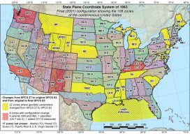
NGS Webinar on State Plane Coord. System Update
NGS’s free webinar on the State Plane Coordinate System Update has been rescheduled after the Federal government shutdown. It now will take place on March 7, 2:00 pm EST. Leading it will be Michael Dennis, PE, LS, National Geodetic Survey. NGS will establish the State Plane Coordinate System of 2022 (SPCS2022) as part of modernizing the National Spatial...