
Blog
Geospatial Data United
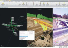
Industry trends are moving toward consolidated environments for data visualization, processing, and management. From the title you might get the impression this article is about a soccer team. To geospatial professionals, however, the title phrase could describe an ideal situation—the ability to handle all geospatial data in a common software environment. A soccer team is made up...
Flying Stockpiles
A team in Colorado is accurately estimating coal stockpile volumetrics with drones. Arch Coal is the second-largest domestic producer of metallurgical and thermal coal in America, with 96 million tons of coal sold in 2016. In total, Arch represents more than 13% of America’s coal supply from their complexes in Colorado, Illinois, Kentucky, West Virginia, Wyoming,...

xyHt Reader Survey
We want to know what you think about us. Help us continue to shape xyHt‘s future by sharing your thoughts in our new reader study. Your opinions can also net you one of five prizes, but you must participate to win. The questionnaire takes 8 to 10 minutes, is multiple choice, and is safe and private....

Virtualization: the Greatest Tool You Don’t (Currently) Use
This post is dedicated to a good friend, Chris Johnson, who, when we worked together a few years back, introduced me to this cool new word: VIRTUALIZATION. You see, Chris is an IT guru (see: enterprise systems architect)—a friend that every GIS guru should have so that you’ve got someone to pick up the pieces...
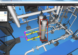
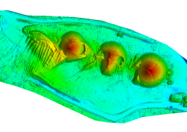
The Value of 360º Digital Panoramic Images
The GeoDude tells us that rich, new deliverables are changing client expectations for the better. One of the biggest impacts that 3D laser scanning has had on the market is a set of new client deliverables that it has spawned. One deliverable in particular (360° panoramic digital images) has profoundly raised the bar of client expectations, yet...

xyHt Weekly News Links: 12/15/17
Transducers USA Introduces New Custom Ultrasonic Sensors Global Aerial Imaging Market – Expected to Reach $3.2 Billion by 2023 – Research and Markets Maptek unveils new strategic panel caving application Is the Newly Revised Geospatial Data Act Worth Supporting? Phase One Industrial Releases iX Capture 3.0 Software for Aerial Photography Geomni Capturing Aerial Imagery of...
Advertisement