
Blog

Layla Gordon, Ordnance Survey Technology Laboratory Engineer
What is the Ordnance Survey Technology Laboratory? I managed to get an interview with one of the UK’s national mapping agency’s engineers, Layla Gordon, who has been working on some interesting geospatial tech. ND: How did your education lead you to OS (Ordnance Survey) and geospatial? LG: Back in 1994 I was doing a degree...

xyHt News Links: 9/9/16
FireFLY6 PRO Now Shipping! Sokkia introduces lighter and faster line of robotic total stations Septentrio’s Altus NR2 GNSS Receiver is Now Offered by Esri Satlab Geosolutions introduces SLX-1 Multi-application CORS GNSS Receiver [Webinar] The Latest Construction Site Land Surveying Practices Phase One Industrial Innovates Four Band Aerial Imaging Phase One Industrial Launches iXU-RS Aerial Camera...

Surveying in the Land of Penguins
The term one-man crew takes on new meaning in Antarctica. In 1841, a U.S. expedition mapped a portion of Antarctica, proving that it was a continent. Generations later, surveyors such as Corey Biddle continue to map and survey the area with the latest equipment. But sometimes the rough conditions in this frozen land–where GPS antenna...
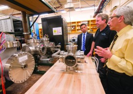
Project Sextant
A unique research study from pioneers in the development of the GPS system yields a plan for a look into the future of PNT—improving resilience, options, flexibility, and availability. When something like GPS puts positioning, navigation, and timing (PNT) in the hands (and pockets) of millions, maybe even billions, of people across the world, experts...
xyHt News Links: 9/2/16
Satlab New Product Announcement: SLC Handheld Four land surveyors share their experiences of using professional drones in their work. Airobotics Selects SimActive’s Photogrammetry Software for its Automated Industrial Drone Solution Carlson Software Releases BRx6 GNSS Receiver New Kespry Drone 2.0 Has Twice the Aerial Coverage senseFly launches new drone Property Drone Consortium and Marion County,...

Pokemon Go: Geospatial Data, All the Time
We want integrated, interoperable systems that are robust and cost-effective Geospatial technology is so entrenched in our daily routines that we often forget we’re using it. I search for map directions at least once a day, whether for a restaurant or for a time of arrival to my daughter’s daycare. And millions of people have...
Advertisement