Blog

xyHt Magazine April 2016 Issue
Click here to view the April 2016 issue of xyHt magazine

xyHt Heights 2016 Supplement
Click here to view the Heights 2016 Supplement to xyHt magazine.

Treasure Hunting and the Treasure Hunt
Editor’s note: The following newspaper article is a view of surveying from the outside that highlights one of the many appealing aspects of surveying that the public might not be aware of. Since its first publication, links to this article rapidly made the rounds of surveying social media; many cite it as a example of...

xyHt Doer: Jeff DeBoer
Jeff DeBoer is program manager of OEM & Mobile Mapping Systems at Topcon Positioning Systems. My main role at Topcon is supporting our customers and working with our mass data collection systems. My responsibilities range from working internally with our engineering teams to help develop and improve products to going out in the field conducting...

xyHt News Links: 3/25/16
Hemisphere GNSS debuts smart antenna for survey New Online Mapping Platform, Azimap, Launched NCEES launches national surveying education award
Prepping for El Niño
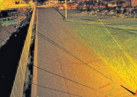
Above: A portion of a roadway that’s subject to flooding was scanned to perform drainage analysis as well as to map the existing conditions. As the severity of weather increases, so do the benefits of high-definition laser scanning for asset management and damage analysis. Editor’s note: Improvements in, and availability of, tools and resources for precise...

