
Blog

xyHt News Links: 3/11/16
Trimble 4D Control Software Supports IBIS-FM Radar Device for Slope Stability and Structural Monitoring in Mining TerraGo Launches On-Demand Solution for Mobile Forms, Inspections and Surveys Topcon announces new geodetic antenna Maptek modelling and exploration technology on show at PDAC Teledyne Optech Press Release: Innovative solutions for bathymetry at Oceanology International 2016 3DR collaborates with...
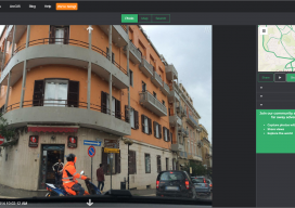
An interview with Mapillary CEO Jan Erik
Following Mapillary’s announcement yesterday, I sought to get more information about Mapillary and how they have come to be such an interesting prospect in the geospatial world. Mapillary is a pioneer in new ways to capture, share, and utilize street-level images. Yesterday I had the privilege to interview Jan Erik Solem of Mapillary to get the...

Visualizing the Perfect Putt
High-definition laser scanned topography-included in golfing greens contours books-elevates putting performance at the U.S. Open. It was two o’clock in the morning and pitch black, except for the red laser of the scanner. It pierced the darkness, accurately tracing the putting green’s profile. Michael O’Brien was enjoying perfect working conditions on the historic Pinehurst No....

Ongoing Adventure
Mini-hydro surveying is wet, wild, and wonder-filled in the Scottish Highlands. When Scottish surveyor Stuart Ross heads to the Highlands to survey for one of the region’s many small-scale hydro schemes (mini-hydro), he always packs his camera. When the rain stops and the sky clears, he wants to capture the view, not just the data. ...
Mapillary Raises $8 Million Series A to Democratize Maps by Connecting the World’s Photos
Technology has made the farthest corners of the planet more accessible than ever before. We can video call loved ones on the other side of the world; and we can view photos of foreign landmarks at the click of a button. At Mapillary, we are taking this accessibility to the next level by letting anyone...

xyHt March 2016 issue
Click here to view the March 2016 issue of xyHt magazine.
Advertisement