
Blog

Encouraging Industry and Professions to Get Smart
What started as a simple Q and A turned into a primer on how, in a very short amount of time, a small, flailing, Swedish company challenged conventional wisdom and grew into a global powerhouse. Familiar to our readers mainly from their Leica Geosystems business (in its ninth year as a division of the parent...
xyHt Links: 8/8/14
3D Laser Mapping Launches Automated Stockpile Volume Solution DigitalGlobe Announces Second 30-Centimeter Satellite to Launch in Mid-2016 Canon Announces Océ PlotWave 500 large format printing system Earle J. Fennell Award for Education Excellence Awarded to PA Society of Land Surveyors Member John G. Fuehrer II, PLS, PE
xyHt Links: 8/5/14
Topcon announces MS AXII measuring station Making Sense of the 2014 Esri International User Conference Supergeo to Provide Free Online GIS Web Courses Phase One Releases iX Capture

xyHt August 2014
Click here to view the August issue of xyHt
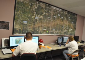
USACE GIS Cadre Mapping Team’s Future
The cadre is a team of Army Corps employees from throughout the nation who are GIS subject-matter experts. When a federally declared disaster occurs the team gets ready to deploy and can be on the ground in just hours, setting up their own equipment even before other agencies are on the scene.

Cardinal Systems’ Extraterrestrial Photogrammetry
On Earth, photogrammetrists can normally use man-made objects in their frame—such as a road of known width or a curb of known height—as scales. When none is present, they can insert such “ground truth” as needed—for example, by placing onto surveyed locations targets that will be visible in their images. On other planets in our...
Advertisement