Category Archives: GNSS/Location Tech
Going for the Long Shot
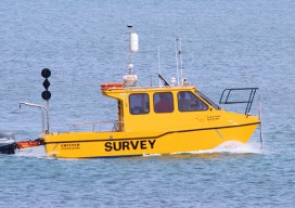
Intuicom’s RTK Bridge has come a long way, including use for hydrographic surveying. Editor’s note: A product name can become a default term for a particular solution; this is the case with the RTK Bridge, a trademark name for the product that Intuicom, radio communications component company, began working on nearly a decade ago. And...

Quantum Navigation
Above: The Royal Navy submarine HMS Astute. Credit: LA(Phot) Paul Halliwell/MOD. Will freezing sub-atomic particles one day supplant GPS as the primary navigation technology? Many of the most accurate measurement devices, including atomic clocks, work by observing how atoms transfer between individual quantum states. The longer the atomic transition can be observed, the more precisely it...
Locata Positioning at Langley Research Center
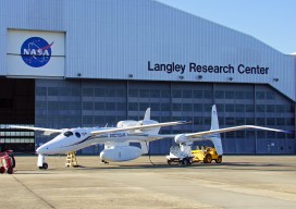
Locata Positioning will Underpin Future Unmanned Aerial System Research at NASA’s Famed Langley Research Center Locata Corporation announced that NASA plans to install a Locata network (LocataNet) as the core positioning technology for safety-critical unmanned aerial systems (UAS) research at its Langley Research Center in Hampton, Virginia. NASA Langley is tasked with performing rigorous and...

Creating Energy From Images
Geospatial information has long played an essential role in the energy industry, but now a new technology is cutting costs while improving the flow of knowledge. Editor’s note: The energy sector, oil and gas in particular, has grown more rapidly in the past half dozen years than in the past half a century. New fields,...
The Clock(s) at the Center of the Universe
To provide precise global time, critical to our digital world, the United States Naval Observatory serves as the major node in a worldwide array of synchronized atomic clocks. For all but a relatively few astronomers and scientists, the universe of humans centers around our earthbound activities and our heuristic sense of time – day, night, seasons,...

I Don’t Need No Stinkin’ Statistics
Surveying Statistics, Part 1 Do you perform GNSS surveys? Do you use OPUS or perform RTK surveys simply because you don’t understand your software’s output? Do you always use the compass-rule adjustment for traverse data simply because that’s the way you have always done it? Do you ever have a situation where you know something...