Category Archives: GNSS/Location Tech
Time to Do More
xyHt has been watching a recent flurry of news releases and webinar announcements from Trimble tagged with the slogan “Time to Do More.” There were quite a few major new products and enhancements announced so we wondered: Was this simply a marketing campaign? Or was this some new direction for Trimble? We decided to ask...
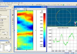
Transformation of Observations, Part 4
Single Project Factor Here concludes a four-part series of articles about transformation of observations, spanning from September and December 2014 to March 2015. Part 1 covers how to transform surface observations into a geocentric coordinate system so that they can be compared to GNSS baseline vectors. Part 2 is about how the creation of a...

Tracking Aircraft in Flight
From surveillance methods using ground-based radar to space-based systems, it’s more complex to track aircraft than you might think. The disappearance of Malaysia Airlines Flight 370 on March 8, 2014, with 239 people on board, was both tragic and stunning. The loss of a modern commercial aircraft operating in government-controlled airspace, which remains unexplained, represents...
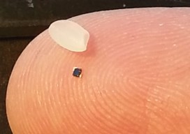
RFID
Above: RFID tags take many forms. The inside of a tag shown above—designed to attach to metal infrastructure in harsh environments, such as water pipes and valves—has a thin copper “bow-tie” antenna with a minuscule chip in the middle. It’s shown contrasted with a grain of rice. An electronic handshake has brought together the worlds...
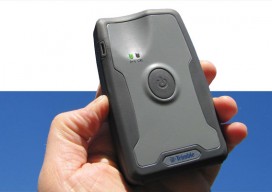
Mapping Peripheral
A review of Trimble’s R1, a GNSS Bluetooth peripheral for mobile devices, with multiple options for correction sources. The idea of a GNSS “puck” has broad appeal: a peripheral GNSS receiver to precision-enable mobile devices such as smart phones, tablets, and a variety of purpose-built field-data-collection devices. There is a lot of functional territory between...

GNSS
Above: The third satellite in IRNSS being tested before its successful launch. What Did Not Happen and Increases, Improvements, Innovations Sometimes the most telling precursors of the future are things that did not happen. By all accounts, 2014 should be remembered a horrible, terrible, very bad GNSS year with botched launches, toxic broadcast ephemerides, near peak...