Category Archives: Lidar/Imaging

Farming From Space
Airbus and Sentinel Fertigation use satellite imagery to improve sustainable crop production With help from Airbus’ detailed high-resolution 30cm satellite imagery provided by Pléiades Neo, a Midwest crop management software platform is offering a streamlined process for farmers fertilizing crops via irrigation (known as fertigation). Using multispectral imagery of field conditions, Lincoln, Nebraska-based Sentinel Fertigation...

Sponsored Content – OneAtlas: Processing Satellite Imagery in the Cloud
Airbus Intelligence provides users with access to satellite imagery, innovative geospatial analytics, and industry-specific insights. Image data from the Airbus Constellation of satellites, which includes twin SPOT 6/7, Vision-1, Pléiades, and Pléiades Neo satellites are used to deliver actionable intelligence to a variety of markets around the globe. Already known for quick processing and delivery...
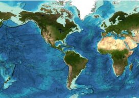
Staying Fluid: The Ocean Decade
More than 23 percent of the ocean seabed is now mapped Seabed 2030 is a partnership between the Nippon Foundation and the General Bathymetric Chart of the Oceans (GEBCO) and aims to map the entire planet’s seabed by 2030. To date, the project has mapped around 23.4 percent of the seabed. The latest data was...
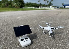
UAS and ALTA Surveys – Part One
Recognizing that with the right equipment and practices, specifications for ALTA surveys can easily be met, surveyors have rapidly adopted UAS for these and many other types of surveys. The adoption of UAS in the surveying profession has been more rapid than some past tech. It was only 2016 when the FAA Part 107...

FARO Buys GeoSLAM
FARO® Technologies, Inc. has bought mobile scanning company GeoSLAM in a effort to expand and accelerate FARO’s market grown opportunity in the mobile scanning space. Founded in 2012, GeoSLAM has grown into a leading provider of mobile scanning solutions with proprietary high-productivity simultaneous localization and mapping (SLAM) software to create 3D models for use in...

Virtual Cities Are Rising
Cutting-edge 3D city models lead the way to better urban planning via digital simulation Take a peek at Helsinki’s virtual 3D city model and what might at first seem to be just rows of solid objects soon reveal themselves as handsome blocks of buildings that line gridiron streets. This is the digital doppelganger of Finland’s...