Category Archives: Lidar/Imaging

Malek Singer
23 Young Geospatial Professionals to Watch in 2023 – 2 of 23 Name: Malek SingerCompany: Teledyne Geospatial (Optech & Caris)Current Position: Product Manager, AirborneAge: 27 Education: BS Geomatics, Carleton University Biography: Singer is passionate about challenging traditional development roadmaps which have historically focused on “delivering more data. He has expanded Teledyne’s roadmap towards products that...
UAS Processing as a Service
Speed, improved workflows, scalability, and analytical tools have boosted the popularity of such services—especially in these times of staffing challenges Creating deliverables from your UAS captured data, orthophotos, point clouds, photo meshes, and terrain models, can put a premium on the skills of your staff and processing resources. This is why an increasing number of...

xyHt Digital Magazine: December 2022
xyHt’s December issue tackles a hodgepodge of subjects, from the what’s going on in the ocean to satellites mapping from space. As always, if you don’t have a subscription to our print edition, or if someone else in the office has snaffled your copy, don’t fret, here is the digital edition. Click here or on the cover...
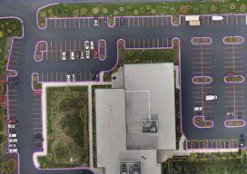
UAS and ALTA Surveys
Part 3 Precision, accuracy, and completeness are the end goals of UAS post processing, but how you get there to meet ALTA standards requires extra care. In Parts One and Two of this article in the September and October 2022 issues of xyHt we looked at the time/cost/precision proposition of using UAS for elements of...

New Digital World Needs Data
Next-generation surveyors require specialized education and training to fill the role of geospatial data specialists. Many emerging geospatial applications, such as digital twins, 3D modeling, monitoring, virtual reality, and autonomous vehicles, are based on big digital datasets. Building a 3D digital world starts with accurate data that ties to a point on the ground, so...
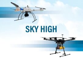
Sky High
UAVs deliver practical and highly technical mobile mapping Collecting imagery with uncrewed aerial vehicles (UAVs) is ideal for a variety of applications including topographic mapping, forestry ground and canopy measurements, powerline corridor mapping, Digital Terrain Model (DTM) generation, high-resolution digital imagery, and orthophoto production, along with support for a variety of other mapping needs. Historically,...