Category Archives: Lidar/Imaging
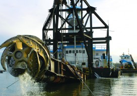
Survey. Dredge. Repeat: Keeping the Columbia River Navigable
As the skipper of Galileo 3, a 30-foot sailboat on the Columbia River, I tell my crew that I am comfortable with 15 feet of water under the keel, get nervous when it drops below 10 feet, and take immediate action if it drops below 6 feet. That’s because I cannot constantly monitor my chart...
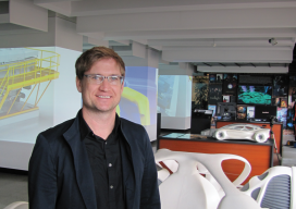
Creating the Futuristic Worlds of 3D
We interviewed Autodesk’s technology futurist Jordan Brandt, appropriately, in the Autodesk Gallery at their One Market offices in San Francisco. The Gallery, open to the public and the venue for monthly techie events, is a showcase for eye-popping examples of the types of innovation Autodesk’s customers have been producing for more than three decades. It...
Pix4D Mapper
Imagine walking up to an object with practically any camera and taking photos of it at different angles. Now imagine uploading those images onto a computer and being able to create a survey-accurate point cloud. Sounds impossible, huh? Too good to be true? That’s what I thought when I first heard of Pix4D. When I...
What is xyHt?
Stand in the place where you live Now face North Think about direction Wonder why you haven’t before “Stand” – R.E.M. Why an obscure geodetic expression? It’s not all that obscure—it represents a foundational element requisite to nearly all human endeavor. It touches your life explicitly and in the abstract. All of the ways that...
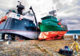
Reality Show Material
So when are they going to do a reality show about us scanner jockeys? The ship owner (I’ll call him Bill) flew me up to Alaska specifically for this project and told me not to worry about anything, that he would arrange for my food and boarding. Usually that means I’m put in a nice...
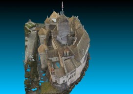
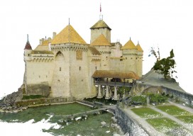
Chillon Castle: A Pix4D Sample Project
Above picture: Point cloud of full model of castle, shown from the top I wrote a review of Pix4D’s Mapper software in the November print issue of xyHt; check it out. Here’s Pix4D’s sample project to showcase the power of their software. They chose to create a model of Switzerland’s most visited site: the Chillon...