Category Archives: Surveying

Get Kids Into Survey
We are once again proud to support Get Kids Into Survey to print and distribute their most recent poster. Click the image below to enlarge.

Title Insurance and Boundary Surveys
Legal Boundaries What many surveyors might not know about title insurance and boundary surveys is they are intricately intertwined, due primarily to the unilateral efforts of the title companies issuing title insurance policies. Unilateral in the sense that the title company can issue a title policy with what is refers to as “survey coverage,” on...

What’s Inside Your GNSS Rover? Part 2
The second installment of a three-part look at the inner workings of high-precision surveying rovers. In Part One of this series (xyHt magazine, September 2023 issue) we focused on the antenna, amplification, and housing elements of rovers. This installment continues with channels, boards, and gates. Channels There is a lot of misunderstanding about what receiver...

Why Opus Projects? Part 2 of 2
OPUS Projects Streamlines Submitting GPS Surveys to National Geodetic Survey By Philippe Hensel with Dan Gillins, Dan Martin and Julie Prusky “Texas Special Reference Center (TSRC) of Conrad Blucher Institute is leading the efforts toward modernization of the horizontal and vertical datums in the State of Texas, particularly in the subsidence zone in southeast Texas....
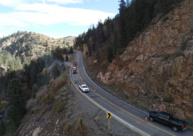
A New Perspective with Drone Photogrammetry
Geotechnical engineers say drones offer a safer, faster method of data collection to identify potential geohazards and assist with mitigation along vulnerable transportation corridors. Mountain roadways are prime locations for geohazards, such as rockfalls, landslides, and debris flows. These events result in road closures, injuries, and property damage, sometimes triggered by thaw/freeze cycles or...
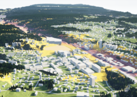
Virtual Reality and City Planning
Engaging citizens to participate actively in urban development projects can often be difficult. But rendering designs in 3D city models and transforming them into immersive virtual reality spaces might just do the trick. When it comes to reshaping cities and constructing new structures, modern architects consider public participation an essential part of creating sustainable and...