Category Archives: Surveying
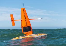
Ocean Mapping Effort Makes Progress
Two new partnerships will advance Seabed 2030’s mission to map the entire ocean floor this decade Since ancient Egyptians began studying the Nile River, bathymetry has been the crucial component in hydrography. The great river gave rise to their great civilization, providing fertile soil for farming, water for irrigation, and a means of transportation...
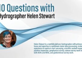
Q&A: 10 Questions with Hydrographer Helen Stewart
Helen Stewart is a multidisciplinary hydrographer with primary focus and expertise in multibeam sonar data processing, including experience in nautical chart surveying, scientific seabed mapping, pipeline inspection, geophysical survey, subsea survey work with both AUVs and ROVs, and geotechnical survey work. How did you get interested in hydrography. Did a specific event trigger your...
The Responsibility to Map the U.S. Coastline
(And the Inevitability of New Geodetic and Tidal Datums) Since the arrival of the first pilgrims to the North American continent, there has been a need for precise knowledge of the coastline of the new country, and the reasons are obvious. Arrival by boat was the only alternative when crossing the Atlantic and escaping religious...

Spring has Sprung
Field Notes Is there a better profession than being a surveyor–especially in the spring? These are the beautiful days we all wait for with anticipation through the cold and windy days of winter. I’ve always felt that when one works outdoors, they freeze all winter for a few nice days in the spring and then...
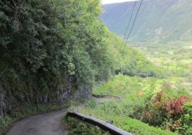
Surveying for Safety at Waipio Valley
Lush vegetation, beautiful ocean vistas, and a historic Hawaiian valley provide the setting for a complex engineering project that addresses technical and cultural concerns. The Waipio Valley on the island of Hawaii has great historical significance within Hawaiian culture. Known as the Valley of Kings, it was home to many generations of the royal family...

The Incredible UAV
Looking Forward Land surveyors aren’t just surveyors anymore. Map makers aren’t just cartographers anymore. We are all tied together in these geospatial professions of measuring, mapping, photogrammetry—anyone who collects and interprets data. We are ‘geospatialists.’ One of the things that tie all of us together is uncrewed aerial vehicles. A few years ago, who would...